Home > Historic > Ancient civilizations > Roman Empire > Roman emperors
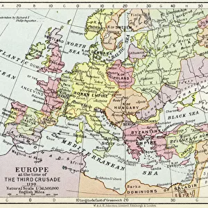
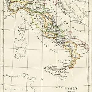
Map Eastern Roman Empire C. 500 AD Theodoric

![]()
Wall Art and Photo Gifts from Design Pics
Map Eastern Roman Empire C. 500 AD Theodoric
Map of the Eastern Roman Empire c. 500 AD, when Theodoric was king of Italy and Sicily and nominally subject to the emperor at Constantinople. From the book Outline of History by H.G. Wells, published 1920
Design Pics offers Distinctively Different Imagery representing over 1,500 contributors
Media ID 32815197
© Ken Welsh
Cartography Chart Constantinople Countries Eastern Emperor Geographical Geography Italy King Roman Empire Sicily Subject Theodoric
FEATURES IN THESE COLLECTIONS
> Europe
> Italy
> Sicily
> Related Images
> Historic
> Ancient civilizations
> Roman Empire
> Roman art
> Historic
> Ancient civilizations
> Roman Empire
> Roman emperors
> Maps and Charts
> Early Maps
> Maps and Charts
> Italy
EDITORS COMMENTS
This print showcases a historical map of the Eastern Roman Empire circa 500 AD, during the reign of Theodoric as king of Italy and Sicily. Despite being nominally subject to the emperor at Constantinople, Theodoric's influence is vividly depicted in this cartographic masterpiece. Published in 1920 as part of H. G. Wells' Outline of History, this engraving offers an invaluable glimpse into the geographical landscape and political divisions of that era. The intricate details captured within this archival piece transport us back in time, allowing us to explore the various countries and territories that constituted the Eastern Roman Empire. Its vintage charm adds a touch of nostalgia to any space it graces, making it a perfect addition for history enthusiasts or collectors alike. With its rich historical significance and impeccable illustration, this picture serves as both an educational tool and a visual delight. It reminds us of how borders have shifted over time while highlighting key figures like Theodoric who left their mark on ancient civilizations. Whether displayed in a classroom or adorning your personal study, this map print is sure to spark curiosity and ignite conversations about our shared past. Let yourself be transported through time with this remarkable piece from Ken Welsh's collection – an exquisite fusion of artistry and history.
MADE IN THE USA
Safe Shipping with 30 Day Money Back Guarantee
FREE PERSONALISATION*
We are proud to offer a range of customisation features including Personalised Captions, Color Filters and Picture Zoom Tools
SECURE PAYMENTS
We happily accept a wide range of payment options so you can pay for the things you need in the way that is most convenient for you
* Options may vary by product and licensing agreement. Zoomed Pictures can be adjusted in the Cart.