Home > Europe > United Kingdom > England > Maps
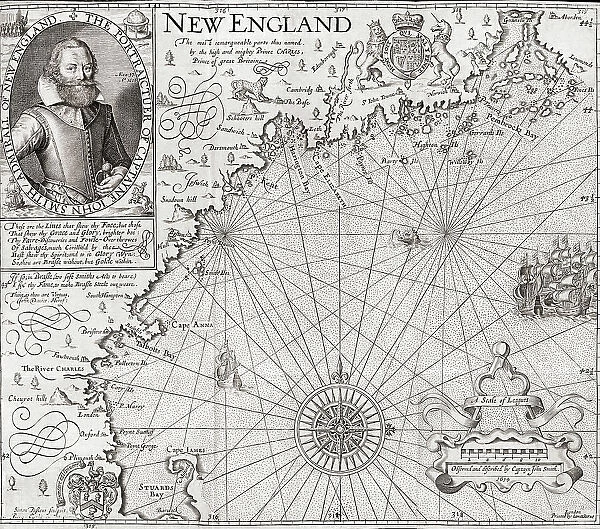
Map New England John Smith Portrait The Generall Historie
![]()

Wall Art and Photo Gifts from Design Pics
Map New England John Smith Portrait The Generall Historie
Map of New England including a portrait of John Smith who helped establish Jamestown and later was the third president of the settlement's governing council. The map was engraved by Simon van de Pass and included in Smith's book The generall historie of Virginia, New-England, and the Summer Isles, 1629 edition
Design Pics offers Distinctively Different Imagery representing over 1,500 contributors
Media ID 32815237
© Ken Welsh
17th Century Cartography Drawing Geographical Geography New England John Smith Map Making
FEATURES IN THESE COLLECTIONS
> Arts
> Realistic drawings
> Portrait drawings
> Fine art
> Europe
> United Kingdom
> England
> Maps
> Maps and Charts
> Early Maps
> North America
> United States of America
> Maps
> North America
> United States of America
> Virginia
> Related Images
EDITORS COMMENTS
This print showcases a remarkable piece of history - a map of New England from the 17th century, accompanied by a portrait of the influential figure, John Smith. The map was meticulously engraved by Simon van de Pass and featured in Smith's renowned book, "The generall historie of Virginia, New-England, and the Summer Isles" specifically in its 1629 edition. John Smith played an instrumental role in establishing Jamestown and later served as the third president of the settlement's governing council. His contributions to early American colonization cannot be overstated. This exquisite illustration not only provides geographical insights into New England during that era but also immortalizes one of America's founding fathers. As we delve into this archival gem, we are transported back in time to witness the intricate artistry involved in cartography during this period. The vintage engraving exudes an air of authenticity and serves as a testament to our rich historical heritage. Ken Welsh has masterfully captured this significant artifact through his lens, allowing us to appreciate its beauty and significance even centuries later. Whether you are an avid history enthusiast or simply intrigued by old-world charm, this print is sure to captivate your imagination and transport you on a journey through time.
MADE IN THE USA
Safe Shipping with 30 Day Money Back Guarantee
FREE PERSONALISATION*
We are proud to offer a range of customisation features including Personalised Captions, Color Filters and Picture Zoom Tools
SECURE PAYMENTS
We happily accept a wide range of payment options so you can pay for the things you need in the way that is most convenient for you
* Options may vary by product and licensing agreement. Zoomed Pictures can be adjusted in the Cart.


