Home > Historic > Ancient civilizations > Roman Empire > Roman art
Map Roman Empire Dominions Time Trajan 1st Century AD

![]()
Wall Art and Photo Gifts from Design Pics
Map Roman Empire Dominions Time Trajan 1st Century AD
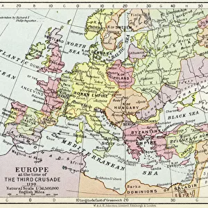
Map of the Roman Empire in the time of Trajan. From the book Outline of History by H.G. Wells, published 1920
Design Pics offers Distinctively Different Imagery representing over 1,500 contributors
Media ID 32815181
© Ken Welsh
Cartography Chart Countries Dominions Geographical Geography Roman Empire Time 1st Century Ad 2nd Century Ad Trajan
FEATURES IN THESE COLLECTIONS
> Historic
> Ancient civilizations
> Roman Empire
> Roman art
> Maps and Charts
> Early Maps
EDITORS COMMENTS
This print showcases a remarkable piece of history - a map depicting the dominions of the Roman Empire during the reign of Trajan in the 1st century AD. Taken from H. G. Wells' renowned book, "Outline of History" published in 1920, this engraving offers an intriguing glimpse into ancient cartography. The intricate details and accuracy presented in this archival illustration make it an invaluable resource for historians and geography enthusiasts alike. The map vividly displays the various countries and territories that comprised the vast Roman Empire at its zenith, providing a visual representation of its expansive reach. As we gaze upon this vintage picture, we are transported back to a bygone era when Rome reigned supreme over much of Europe, North Africa, and parts of Asia. It serves as a reminder of Rome's immense power and influence during this period. The historical significance captured within this image is awe-inspiring. It allows us to appreciate how geographical boundaries have evolved over time while offering insights into political dynamics and cultural exchanges between different regions. Ken Welsh's expert craftsmanship ensures that every detail is brought to life with precision, making this print not only visually stunning but also academically valuable. Whether displayed in homes or educational institutions, it serves as both an artistic masterpiece and an educational tool for those eager to explore ancient civilizations through cartographic lenses.
MADE IN THE USA
Safe Shipping with 30 Day Money Back Guarantee
FREE PERSONALISATION*
We are proud to offer a range of customisation features including Personalised Captions, Color Filters and Picture Zoom Tools
SECURE PAYMENTS
We happily accept a wide range of payment options so you can pay for the things you need in the way that is most convenient for you
* Options may vary by product and licensing agreement. Zoomed Pictures can be adjusted in the Cart.