Home > Europe > Italy > Sicily > Messina
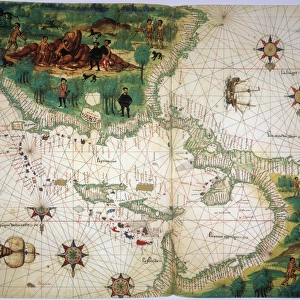
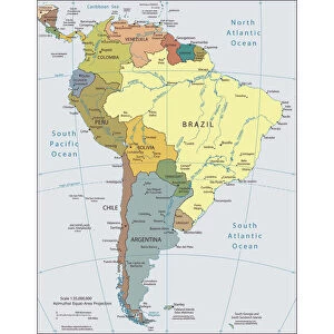
Map Of America. Reduced Facsimile Of A Map From The Spanish Atlas Published In Messina, 1582. From Science And Literature In The Middle Ages By Paul Lacroix Published London 1878

![]()
Wall Art and Photo Gifts from Design Pics
Map Of America. Reduced Facsimile Of A Map From The Spanish Atlas Published In Messina, 1582. From Science And Literature In The Middle Ages By Paul Lacroix Published London 1878
Design Pics offers Distinctively Different Imagery representing over 1,500 contributors
Media ID 18190151
© Ken Welsh / Design Pics
Ages Cartography Geography Mapmaking Mediaeval Medieval Middle
FEATURES IN THESE COLLECTIONS
> Arts
> Art Movements
> Medieval Art
> Arts
> Literature
> Illustration
> Arts
> Literature
> Europe
> Italy
> Sicily
> Messina
> Europe
> Spain
> Related Images
> Maps and Charts
> Related Images
> Maps and Charts
> Spain
EDITORS COMMENTS
This print showcases a remarkable piece of history - a reduced facsimile of a map from the Spanish Atlas published in Messina, 1582. Taken from Paul Lacroix's renowned book "Science and Literature in the Middle Ages" which was published in London back in 1878, this image transports us to an era when cartography was still in its infancy. The Map of America depicted here is not only visually stunning but also serves as a testament to the incredible advancements made during medieval times. It offers us a glimpse into how people perceived geography and explored new territories centuries ago. Every intricate detail on this map tells a story - from the uncharted lands waiting to be discovered to the mythical creatures that once captured imaginations. The artistry involved in creating such maps is truly awe-inspiring, showcasing both scientific knowledge and artistic skill. Ken Welsh's expert photography captures every nuance of this historical artifact, allowing us to appreciate its beauty and significance even today. This image invites us to reflect on our own understanding of America's past while marveling at how far we have come since these early attempts at mapping our world. Whether you are fascinated by cartography or simply intrigued by history, this print will undoubtedly transport you back through time, offering endless opportunities for exploration and discovery within its intricate lines and vibrant colors.
MADE IN THE USA
Safe Shipping with 30 Day Money Back Guarantee
FREE PERSONALISATION*
We are proud to offer a range of customisation features including Personalised Captions, Color Filters and Picture Zoom Tools
SECURE PAYMENTS
We happily accept a wide range of payment options so you can pay for the things you need in the way that is most convenient for you
* Options may vary by product and licensing agreement. Zoomed Pictures can be adjusted in the Cart.