Home > Europe > United Kingdom > Scotland > Maps
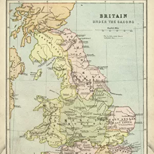
Map Of Britain Angles Saxons Early Middle Ages

![]()
Wall Art and Photo Gifts from Design Pics
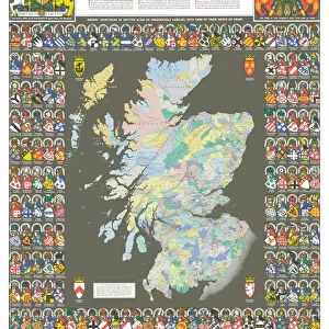
Map Of Britain Angles Saxons Early Middle Ages
Map of Britain under the Angles and Saxons. From History of England, 55B.C. to the present time, published 1907
Design Pics offers Distinctively Different Imagery representing over 1,500 contributors
Media ID 31610879
© Hilary Morgan
Angles Cartography Geographical Geography Scotland Wales Dark Ages Early Middle Ages Saxons
FEATURES IN THESE COLLECTIONS
> Arts
> Art Movements
> Medieval Art
> Europe
> United Kingdom
> England
> Maps
> Europe
> United Kingdom
> Scotland
> Maps
> Europe
> United Kingdom
> Scotland
> Posters
> Europe
> United Kingdom
> Scotland
> Related Images
> Europe
> United Kingdom
> Wales
> Maps
> Europe
> United Kingdom
> Wales
> Posters
> Europe
> United Kingdom
> Wales
> Related Images
> Maps and Charts
> Early Maps
> Maps and Charts
> Related Images
EDITORS COMMENTS
This print showcases a historical treasure - the "Map of Britain under the Angles and Saxons". Dating back to the early Middle Ages, this archival piece offers a glimpse into the fascinating past of England, Wales, and Scotland. Published in 1907 as part of the renowned "History of England" series by Hilary Morgan, this map is an invaluable resource for those interested in delving deeper into British history. The intricate cartography beautifully illustrates how these ancient tribes shaped the geographical landscape during the early medieval period. As one explores this vintage engraving, they are transported to a time often referred to as the Dark Ages. The picture captures not only borders but also provides insight into cultural shifts that occurred during this transformative era. With its rich historical context and detailed illustration style, this print serves as both an educational tool and a work of art. It invites viewers to ponder upon how nations evolve over time while appreciating the skillful craftsmanship behind such maps from yesteryears. Whether you are an avid historian or simply captivated by vintage aesthetics, this Map of Britain will undoubtedly ignite your curiosity about our collective past. Let it transport you through time and space as you explore the roots that have shaped modern-day England, Wales, and Scotland.
MADE IN THE USA
Safe Shipping with 30 Day Money Back Guarantee
FREE PERSONALISATION*
We are proud to offer a range of customisation features including Personalised Captions, Color Filters and Picture Zoom Tools
SECURE PAYMENTS
We happily accept a wide range of payment options so you can pay for the things you need in the way that is most convenient for you
* Options may vary by product and licensing agreement. Zoomed Pictures can be adjusted in the Cart.