Home > Maps and Charts > Early Maps
Map Europe European 1930's 20th Century Country

![]()
Wall Art and Photo Gifts from Design Pics
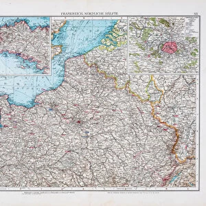
Map Europe European 1930's 20th Century Country
Map of Europe in the 1930's. From The Wonderland of Knowledge, published c.1930
Design Pics offers Distinctively Different Imagery representing over 1,500 contributors
Media ID 31611655
© Hilary Morgan
1930s 20th Century Countries Geographical Geogrpahy
FEATURES IN THESE COLLECTIONS
> Maps and Charts
> Early Maps
> Maps and Charts
> Related Images
EDITORS COMMENTS
This print takes us back in time to the 1930s, offering a glimpse into the geopolitical landscape of Europe during that era. The Map of Europe featured here is sourced from "The Wonderland of Knowledge" a publication dating back to approximately 1930. With its intricate engravings and vibrant colors, this archival piece showcases the geographical boundaries and divisions that shaped European countries during this pivotal period in history. As we examine this vintage illustration, it becomes evident how much has changed since then. Borders have shifted, nations have risen and fallen, and new alliances have been forged. This map serves as a reminder of the ever-evolving nature of our world. Beyond its historical significance, Hilary Morgan's expertly captured photograph allows us to appreciate the artistry involved in creating such maps during that time. The attention to detail is remarkable; every line meticulously drawn, every color carefully chosen. Whether you are an avid historian or simply intrigued by vintage aesthetics, this print will transport you to an era long gone but not forgotten. It invites contemplation on how geography shapes politics and cultures while serving as a testament to human curiosity about our place in the world
MADE IN THE USA
Safe Shipping with 30 Day Money Back Guarantee
FREE PERSONALISATION*
We are proud to offer a range of customisation features including Personalised Captions, Color Filters and Picture Zoom Tools
SECURE PAYMENTS
We happily accept a wide range of payment options so you can pay for the things you need in the way that is most convenient for you
* Options may vary by product and licensing agreement. Zoomed Pictures can be adjusted in the Cart.