Home > Europe > United Kingdom > England > Maps
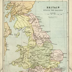
Map Roman Britain Area Island Ruled Governed

![]()
Wall Art and Photo Gifts from Design Pics
Map Roman Britain Area Island Ruled Governed
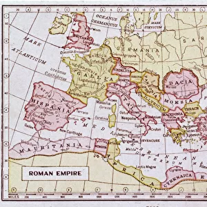
Map of Roman Britain showing the area of the island of Great Britain that was ruled by the Roman Empire, 43 - 410 AD
Design Pics offers Distinctively Different Imagery representing over 1,500 contributors
Media ID 31611337
© Hilary Morgan
Ancient Area Britain Cartography Chart Civilizations Empire Geographical Geography Great Great Britain Roman Governed Ruled
FEATURES IN THESE COLLECTIONS
> Arts
> Artists
> R
> Roman Roman
> Europe
> United Kingdom
> England
> Maps
> Historic
> Ancient civilizations
> Roman Empire
> Roman art
> Historic
> Ancient civilizations
> Roman Empire
> Historic
> Ancient civilizations
> Maps and Charts
> British Empire Maps
> Maps and Charts
> Early Maps
> Maps and Charts
> Related Images
EDITORS COMMENTS
This photo print, titled "Map Roman Britain Area Island Ruled Governed" takes us back in time to the era when Great Britain was under the rule of the mighty Roman Empire. Created by talented artist Hilary Morgan, this vintage illustration showcases a meticulously detailed map that depicts the extent of Roman control over the island from 43 to 410 AD. The map serves as a fascinating historical document, shedding light on ancient civilizations and their impact on British history. It offers a glimpse into how geography played a crucial role in shaping political boundaries during that period. The intricate engraving and careful cartography make it an invaluable archival piece for those interested in studying or appreciating our past. As we explore this snapshot of history, we are reminded of England's rich heritage and its ties to one of the most influential empires in human civilization. This artwork invites us to reflect upon how these ancient societies governed vast territories with remarkable precision despite limited technological advancements. Whether you're an enthusiast of cartography, fascinated by ancient civilizations, or simply intrigued by historical illustrations, this picture is sure to captivate your imagination. Let yourself be transported through time as you delve into the intricacies and significance behind each line and contour on this remarkable vintage map.
MADE IN THE USA
Safe Shipping with 30 Day Money Back Guarantee
FREE PERSONALISATION*
We are proud to offer a range of customisation features including Personalised Captions, Color Filters and Picture Zoom Tools
SECURE PAYMENTS
We happily accept a wide range of payment options so you can pay for the things you need in the way that is most convenient for you
* Options may vary by product and licensing agreement. Zoomed Pictures can be adjusted in the Cart.