Home > Maps and Charts > Early Maps
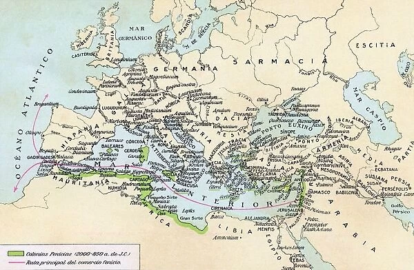
Phoenician Colonies And Area Of Influence In The Mediterranean 200 To 850 B. C. Green Shows Colonized Areas. Red Shows Principal Routes Of Phoenician Commerce. From Historia De Las Naciones Published Circa 1921
![]()

Wall Art and Photo Gifts from Design Pics
Phoenician Colonies And Area Of Influence In The Mediterranean 200 To 850 B. C. Green Shows Colonized Areas. Red Shows Principal Routes Of Phoenician Commerce. From Historia De Las Naciones Published Circa 1921
Phoenician Colonies And Area Of Influence In The Mediterranean 200 To 850 B.C. Green Shows Colonized Areas. Red Shows Principal Routes Of Phoenician Commerce. From Historia De Las Naciones Published Circa 1921
Design Pics offers Distinctively Different Imagery representing over 1,500 contributors
Media ID 18190306
© Ken Welsh / Design Pics
Ancient Area Cities Colonies Colony Commerce Commercial Influence Mediterranean Route Routes Times Towns Phoenicia Phoenician
FEATURES IN THESE COLLECTIONS
> Maps and Charts
> Early Maps
> Maps and Charts
> Related Images
EDITORS COMMENTS
This print showcases the Phoenician colonies and their area of influence in the Mediterranean from 200 to 850 B. C. The vibrant green hues highlight the colonized areas, while the striking red lines depict the principal routes of Phoenician commerce. Published circa 1921 in Historia De Las Naciones, this illustration provides a fascinating glimpse into ancient times. The map reveals how Phoenicia's commercial prowess extended far beyond its own borders, as it established thriving colonies and trade networks throughout the Mediterranean region. These influential city-states played a crucial role in shaping maritime trade during this era. As we explore this historical snapshot, we can imagine bustling towns and cities along these renowned routes. The Phoenicians' mastery of seafaring allowed them to navigate vast distances with ease, connecting various cultures and facilitating prosperous exchanges of goods and ideas. This image not only serves as a testament to Phoenicia's economic power but also highlights its significant cultural impact on surrounding civilizations. Through their extensive network of colonies and trade routes, they left an indelible mark on history that continues to resonate today. Ken Welsh's skillful capture brings this ancient world back to life, inviting us to delve into the rich tapestry of Phoenician civilization and appreciate their enduring legacy in shaping our modern understanding of commerce and international relations.
MADE IN THE USA
Safe Shipping with 30 Day Money Back Guarantee
FREE PERSONALISATION*
We are proud to offer a range of customisation features including Personalised Captions, Color Filters and Picture Zoom Tools
SECURE PAYMENTS
We happily accept a wide range of payment options so you can pay for the things you need in the way that is most convenient for you
* Options may vary by product and licensing agreement. Zoomed Pictures can be adjusted in the Cart.


