Home > Europe > Montenegro > Maps
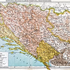
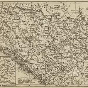
Map of the Herzegovina, Bosnia, Servia and Montenegro (engraving)
")
![]()
Wall Art and Photo Gifts from Fine Art Finder
Map of the Herzegovina, Bosnia, Servia and Montenegro (engraving)
1105886 Map of the Herzegovina, Bosnia, Servia and Montenegro (engraving) by European School, (19th century); Private Collection; (add.info.: Map of the Herzegovina, Bosnia, Servia and Montenegro. Illustration for The Illustrated London News, 29 January 1876.); Look and Learn / Illustrated Papers Collection
Media ID 23048872
© Look and Learn / Illustrated Papers Collection / Bridgeman Images
Balkans Bosnia Herzegovina Montenegrin Montenegro Serbia Serbian Servia
FEATURES IN THESE COLLECTIONS
> Arts
> Artists
> M
> Montenegran School Montenegran School
> Europe
> Bosnia and Herzegovina
> Maps
> Europe
> Montenegro
> Maps
> Europe
> Montenegro
> Posters
> Europe
> Montenegro
> Related Images
> Europe
> Serbia
> Related Images
> Fine Art Finder
> Artists
> European School
> Fine Art Finder
> Artists
> French School
> Fine Art Finder
> Temp Classification
> Maps and Charts
> Bosnia and Herzegovina
> Maps and Charts
> Montenegro
EDITORS COMMENTS
This engraving from the 19th century takes us on a visual journey through the heart of the Balkans. The intricate details and delicate lines of this "Map of Herzegovina, Bosnia, Servia, and Montenegro" transport us back to a time when cartography was not only an art form but also a means to understand uncharted territories. As we gaze upon this historical treasure, we are reminded of the rich cultural tapestry that encompasses these lands. From the rugged landscapes of Herzegovina to the enchanting valleys of Bosnia, each region is meticulously depicted with precision and care. This map serves as a testament to both European School's mastery in engraving techniques and their dedication to accurately representing geographical features. The inclusion of Servia (now Serbia) and Montenegro further adds depth to our exploration. These nations, once part of larger empires, now stand proudly as independent entities within Europe's complex history. The borders delineated on this print tell stories untold; tales woven by centuries-long struggles for independence and self-determination. It is fascinating how maps can transcend time and space, allowing us glimpses into worlds long gone. As we examine this Map of Herzegovina, Bosnia, Servia, and Montenegro today—over 150 years after its creation—we are reminded that geography is not merely about physical boundaries but also about human connections that shape our collective identity. This remarkable piece from Bridgeman Images' collection invites us to ponder upon the ever-evolving
MADE IN THE USA
Safe Shipping with 30 Day Money Back Guarantee
FREE PERSONALISATION*
We are proud to offer a range of customisation features including Personalised Captions, Color Filters and Picture Zoom Tools
SECURE PAYMENTS
We happily accept a wide range of payment options so you can pay for the things you need in the way that is most convenient for you
* Options may vary by product and licensing agreement. Zoomed Pictures can be adjusted in the Cart.