Home > Arts > Portraits > Pop art gallery > Street art portraits
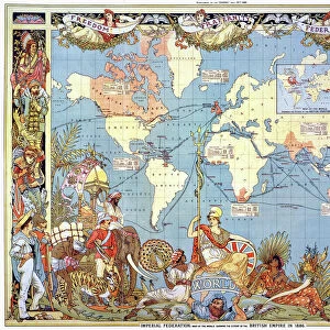
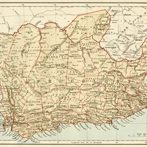
The British Empire showing the Great Commercial Highways (colour litho)
")
![]()
Wall Art and Photo Gifts from Fine Art Finder
The British Empire showing the Great Commercial Highways (colour litho)
7169494 The British Empire showing the Great Commercial Highways (colour litho) by English School, (20th century); Private Collection; (add.info.: The British Empire showing the Great Commercial Highways. Illustration for The Harmsworth Universal Atlas and Gazetteer (Amalgamated Press, c 1906).); © Look and Learn
Media ID 24754630
© Look and Learn / Bridgeman Images
Atlas City Map City Plan General Map Street Plan Mythological Figure Pagan Paganism Pagans Polytheism Polytheist
FEATURES IN THESE COLLECTIONS
> Arts
> Portraits
> Pop art gallery
> Street art portraits
> Fine Art Finder
> Artists
> English School
> Fine Art Finder
> Artists
> Oscar Bluhm
> Maps and Charts
> British Empire Maps
> Maps and Charts
> Early Maps
> Maps and Charts
> Related Images
> Popular Themes
> Religious Images
The British Empire showing the Great Commercial Highways - A Glimpse into a Mythical World
EDITORS COMMENTS
. This photo print, titled "The British Empire showing the Great Commercial Highways" takes us on a mesmerizing journey through time and space. Created by an anonymous English School artist in the early 20th century, this colour lithograph is a true testament to artistic brilliance. Within its intricate details lies a map that not only showcases the vast expanse of the British Empire but also reveals an enchanting blend of mythological figures and characters. This fusion of mythology with cartography transports us to a realm where ancient gods and goddesses coexist with modern civilization. As we explore this extraordinary piece, we are reminded of the rich tapestry of religious beliefs that have shaped human history. Paganism, polytheism, and various religions come alive as vibrant colours breathe life into each illustration. The city plans and street maps depicted here provide glimpses into bustling metropolises within the empire's dominion. The lithographic technique used adds depth and texture to every stroke, making it feel like we are peering into another world altogether. This artwork was originally featured in The Harmsworth Universal Atlas and Gazetteer published around 1906. Today, it resides in a private collection where its beauty continues to captivate viewers from all walks of life. "The British Empire showing the Great Commercial Highways" invites us to embark on an imaginative voyage through history while celebrating both artistry and cultural diversity
MADE IN THE USA
Safe Shipping with 30 Day Money Back Guarantee
FREE PERSONALISATION*
We are proud to offer a range of customisation features including Personalised Captions, Color Filters and Picture Zoom Tools
SECURE PAYMENTS
We happily accept a wide range of payment options so you can pay for the things you need in the way that is most convenient for you
* Options may vary by product and licensing agreement. Zoomed Pictures can be adjusted in the Cart.