Home > Asia > India > Maps
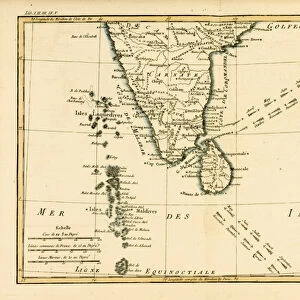
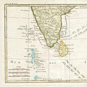
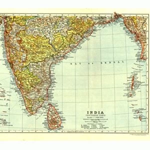
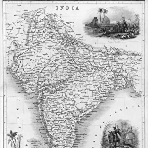
Map of southern India 1896

![]()
Wall Art and Photo Gifts from Fine Art Storehouse
Map of southern India 1896
Andres Allgemeiner Handatlas - Bielefeld und Leipzig 1896
Unleash your creativity and transform your space into a visual masterpiece!
THEPALMER
Media ID 18357079
FEATURES IN THESE COLLECTIONS
> Asia
> India
> Related Images
> Fine Art Storehouse
> Map
> Historical Maps
> Maps and Charts
> India
> Maps and Charts
> Related Images
EDITORS COMMENTS
In this print titled "Map of southern India 1896" we are transported back in time to the late 19th century. The intricate details and rich colors of this vintage map, sourced from Andres Allgemeiner Handatlas - Bielefeld und Leipzig 1896, offer a fascinating glimpse into the geographical landscape of southern India during that era. As our eyes wander across the image, we can appreciate the meticulous craftsmanship that went into creating such an informative piece. Every contour line, river system, and city is meticulously marked with precision and care. This map serves as a testament to both the artistry and scientific accuracy present in cartography at the turn of the century. The warm hues used in this print evoke a sense of nostalgia while simultaneously highlighting key features on the map. From bustling cities like Chennai (then known as Madras) to serene coastal regions along the Bay of Bengal, each location holds its own unique charm within this historical representation. "The Map of Southern India 1896" by THEPALMER takes us on a visual journey through time, allowing us to explore not only geographical boundaries but also cultural heritage and historical significance. It reminds us how maps serve as gateways to understanding our past and appreciating our present surroundings. This fine art print from Fine Art Storehouse is sure to captivate history enthusiasts or anyone seeking an exquisite piece that seamlessly combines aesthetics with knowledge about one's roots or travel aspirations.
MADE IN THE USA
Safe Shipping with 30 Day Money Back Guarantee
FREE PERSONALISATION*
We are proud to offer a range of customisation features including Personalised Captions, Color Filters and Picture Zoom Tools
SECURE PAYMENTS
We happily accept a wide range of payment options so you can pay for the things you need in the way that is most convenient for you
* Options may vary by product and licensing agreement. Zoomed Pictures can be adjusted in the Cart.