Home > Arts > Street art graffiti > Digital art > Vector illustrations
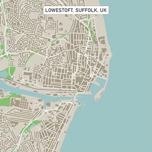
Fairfield California US City Street Map

![]()
Wall Art and Photo Gifts from Fine Art Storehouse
Fairfield California US City Street Map
Vector Illustration of a City Street Map of Fairfield, California, USA. Scale 1:60, 000.
All source data is in the public domain.
U.S. Geological Survey, US Topo
Used Layers:
USGS The National Map: National Hydrography Dataset (NHD)
USGS The National Map: National Transportation Dataset (NTD)
Unleash your creativity and transform your space into a visual masterpiece!
Frank Ramspott
Media ID 15055077
© Frank Ramspott, all rights reserved
Aerial View California City Map Computer Graphic Directly Above Downtown District Fairfield Gray Road Map Text Digitally Generated Image Green Color White Color
FEATURES IN THESE COLLECTIONS
> Aerial Photography
> Related Images
> Animals
> Insects
> Hemiptera
> Green Scale
> Animals
> Mammals
> Cricetidae
> California Mouse
> Arts
> Contemporary art
> Digital artwork
> Street art
> Arts
> Landscape paintings
> Waterfall and river artworks
> River artworks
> Arts
> Portraits
> Pop art gallery
> Street art portraits
> Arts
> Street art graffiti
> Digital art
> Digital paintings
> Arts
> Street art graffiti
> Digital art
> Vector illustrations
> Fine Art Storehouse
> Map
> Street Maps
> Fine Art Storehouse
> Map
> USA Maps
> Maps and Charts
> Geological Map
> Maps and Charts
> Related Images
EDITORS COMMENTS
This print showcases a meticulously detailed city street map of Fairfield, California, USA. Created with precision and care, the vector illustration captures the essence of this vibrant city. With a scale of 1:60,000, every road, river, lake, and district is beautifully rendered. The source data used in this artwork is all from the public domain. The U. S. Geological Survey's National Hydrography Dataset (NHD) and National Transportation Dataset (NTD) were instrumental in creating this masterpiece. The image portrays Fairfield's downtown district surrounded by its natural beauty - rivers flowing gracefully through the landscape and lakes shimmering under the sun. The streets are intricately designed to guide residents and visitors alike through this charming city. Rendered in shades of gray with pops of green and blue accents against a clean white background, this digitally generated image exudes elegance and sophistication. Its aerial perspective offers a unique viewpoint directly above Fairfield. Textual elements provide additional information while maintaining an unobtrusive presence within the composition. This visually striking piece combines cartography with modern design techniques to create an artful representation of Fairfield's physical geography. Frank Ramspott skillfully brings together technology and creativity to produce this stunning work that celebrates Fairfield's urban charm without featuring any people or commercial aspects. A must-have for lovers of maps or anyone seeking to adorn their space with a sophisticated touch!
MADE IN THE USA
Safe Shipping with 30 Day Money Back Guarantee
FREE PERSONALISATION*
We are proud to offer a range of customisation features including Personalised Captions, Color Filters and Picture Zoom Tools
SECURE PAYMENTS
We happily accept a wide range of payment options so you can pay for the things you need in the way that is most convenient for you
* Options may vary by product and licensing agreement. Zoomed Pictures can be adjusted in the Cart.