Home > Europe > France > Canton > Nord
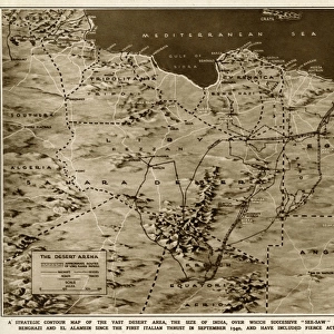
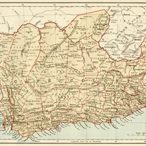
Carte administrative de l'Algerie; Afrique du nord, 1914. Creator: Unknown

![]()
Wall Art and Photo Gifts from Heritage Images
Carte administrative de l'Algerie; Afrique du nord, 1914. Creator: Unknown
Carte administrative de l'Algerie; Afrique du nord, 1914. From "Grande Geographie Bong Illustree", 1914
Heritage Images features heritage image collections
Media ID 36294965
© The Print Collector/Heritage Images
Admin Administration Administrative Algeria Algerian Cartography Cities Map Making Mapmaking Mediterranean Sea North Africa North African Railway Line Railway Lines Railway Track Railway Tracks Train Track
FEATURES IN THESE COLLECTIONS
> Africa
> Algeria
> Related Images
> Europe
> France
> Canton
> Nord
> Maps and Charts
> Related Images
> Popular Themes
> Railway Posters
EDITORS COMMENTS
This vintage print, titled 'Carte administrative de l'Algérie; Afrique du Nord, 1914,' offers a fascinating glimpse into the administrative divisions and geographical features of Algeria during the early 20th century. The map, published in the renowned French geographical magazine 'Grande Geographie Bong Illustree' in 1914, showcases the intricate network of administrative divisions, cities, and railways that crisscrossed this North African country, which was then under French rule. The map is adorned with an array of vibrant colors and intricate engravings, highlighting the major cities, rivers, mountains, and coastline of Algeria. The Mediterranean Sea is depicted in a rich blue hue, with the coastal cities and towns meticulously outlined. The extensive railway system is clearly visible, with numerous railway lines and tracks weaving through the landscape, connecting the major urban centers and facilitating transportation and commerce. The map is a testament to the meticulous work of the cartographers and mapmakers of the time, who painstakingly documented the ever-evolving administrative and geographical landscape of Algeria. The print serves as an important historical record, providing valuable insights into the administrative divisions and transportation infrastructure of North Africa during the early 1900s. The 'Carte administrative de l'Algérie; Afrique du Nord, 1914' is an intriguing and visually stunning piece of cartographic history, offering a captivating glimpse into the past and the rich cultural heritage of Algeria and North Africa as a whole.
MADE IN THE USA
Safe Shipping with 30 Day Money Back Guarantee
FREE PERSONALISATION*
We are proud to offer a range of customisation features including Personalised Captions, Color Filters and Picture Zoom Tools
SECURE PAYMENTS
We happily accept a wide range of payment options so you can pay for the things you need in the way that is most convenient for you
* Options may vary by product and licensing agreement. Zoomed Pictures can be adjusted in the Cart.