Home > Arts > Minimalist artwork > Monochrome artwork > Monochrome paintings
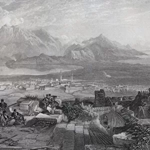
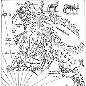
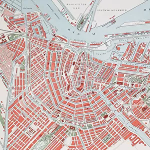
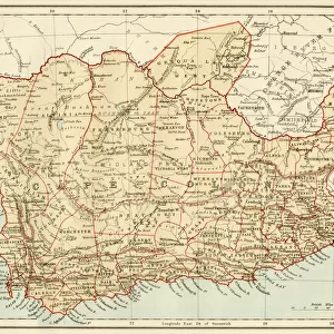
A map of the Cape of Good Hope, South Africa, 1719 (1931)
")
![]()
Wall Art and Photo Gifts from Heritage Images
A map of the Cape of Good Hope, South Africa, 1719 (1931)
A map of the Cape of Good Hope, South Africa, 1719 (1931). Plate taken from Historic Farms of South Africa, by Dorothea Fairbridge, published by Oxford University Press (London, 1931)
Heritage Images features heritage image collections
Media ID 14944827
© The Print Collector / Heritage-Images
Cape Of Good Hope Cartography Dorothea Dorothea Fairbridge Fairbridge Historic Farms Of South Africa Map Making South Africa South African Print Collector8
FEATURES IN THESE COLLECTIONS
> Africa
> South Africa
> Maps
> Arts
> Literature
> Books
> Arts
> Literature
> Arts
> Minimalist artwork
> Monochrome artwork
> Monochrome paintings
> Europe
> United Kingdom
> England
> London
> Related Images
EDITORS COMMENTS
This print showcases a remarkable map of the Cape of Good Hope in South Africa, dating back to 1719. The plate was extracted from the renowned book "Historic Farms of South Africa" authored by Dorothea Fairbridge and published by Oxford University Press in London, 1931. This exquisite piece of cartography offers a glimpse into the geographical features and landscapes that define this beautiful country. The intricate details on this map highlight the majestic mountains that grace the South African terrain, showcasing their prominence as a significant geographical feature. As we delve into its monochrome charm, we are transported back to the 18th century when this masterpiece was created. Dorothea Fairbridge's work serves as an invaluable literary contribution to understanding South Africa's rich history and heritage. Her passion for exploring historic farms across the country shines through her writing, making it an essential resource for those interested in delving deeper into its past. This print is not only a testament to Fairbridge's dedication but also a celebration of African artistry and craftsmanship within cartography. It encapsulates centuries worth of knowledge about this enchanting continent while providing us with insights into its diverse geography. As we admire this vintage treasure curated by The Print Collector, let us appreciate how maps like these continue to inspire curiosity about our world's past and present locations.
MADE IN THE USA
Safe Shipping with 30 Day Money Back Guarantee
FREE PERSONALISATION*
We are proud to offer a range of customisation features including Personalised Captions, Color Filters and Picture Zoom Tools
SECURE PAYMENTS
We happily accept a wide range of payment options so you can pay for the things you need in the way that is most convenient for you
* Options may vary by product and licensing agreement. Zoomed Pictures can be adjusted in the Cart.