Home > Europe > United Kingdom > England > London > Sights > New River
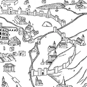
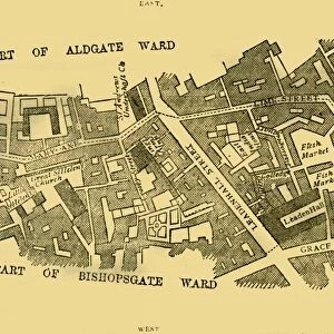
Plan of Roman London, (1897). Creator: Unknown
. Creator: Unknown")
![]()
Wall Art and Photo Gifts from Heritage Images
Plan of Roman London, (1897). Creator: Unknown
Plan of Roman London, (1897). Map showing the area of what is now the City of London, as it might have looked during the Roman period. Places and landmarks shown include Watling Street, Barbican, the various gates in the Roman walls, and the River Thames (Flumen Tamesis in Latin). Also marked is St Pauls Cathedral which would not have been built until centuries later. From Old and New London, Volume I, by Walter Thornbury. [Cassell and Company, Limited, London, Paris & Melbourne, 1897]
Heritage Images features heritage image collections
Media ID 18097299
© The Print Collector / Heritage-Images
Cassell Company Ltd City Walls George Walter George Walter Thornbury Old And New London Publisher Street Plan Thornbury Town Wall Walled City Walls
FEATURES IN THESE COLLECTIONS
> Arts
> Artists
> R
> Roman Roman
> Arts
> Artists
> W
> George White
> Europe
> France
> Paris
> Maps
> Europe
> Italy
> Lazio
> Rome
> Europe
> United Kingdom
> England
> London
> Boroughs
> City of London
> Europe
> United Kingdom
> England
> London
> River Thames
> Europe
> United Kingdom
> England
> London
> Sights
> New River
> Europe
> United Kingdom
> England
> London
> Sights
> St Pauls Cathedral
EDITORS COMMENTS
This print takes us back in time to the Roman period, offering a glimpse into the ancient city of London. Created in 1897 by an unknown artist, this detailed map showcases what is now known as the City of London, with remarkable accuracy for its time. The viewer can trace their eyes along Watling Street, one of the most important Roman roads in Britain, leading towards various gates within the sturdy Roman walls that once encircled this bustling metropolis. The River Thames, referred to as Flumen Tamesis in Latin, gracefully meanders through the heart of this historic landscape. Notably marked on this map is St Paul's Cathedral, although it would not grace London's skyline until many centuries later. This visual representation allows us to appreciate how much has changed over time while marveling at how certain landmarks have stood the test of history. Taken from Walter Thornbury's renowned publication "Old and New London" which was released in 1897 by Cassell and Company Limited, this print offers a valuable insight into both geography and history. It serves as a testament to Thornbury's dedication to documenting London's rich heritage. As we gaze upon this fascinating snapshot from yesteryears' Rome-occupied Londinium (as it was then called), we are reminded of our connection to those who walked these streets centuries ago. It sparks curiosity about their daily lives and leaves us yearning for more knowledge about our shared past.
MADE IN THE USA
Safe Shipping with 30 Day Money Back Guarantee
FREE PERSONALISATION*
We are proud to offer a range of customisation features including Personalised Captions, Color Filters and Picture Zoom Tools
SECURE PAYMENTS
We happily accept a wide range of payment options so you can pay for the things you need in the way that is most convenient for you
* Options may vary by product and licensing agreement. Zoomed Pictures can be adjusted in the Cart.