Home > Arts > Landscape paintings > Waterfall and river artworks > River artworks
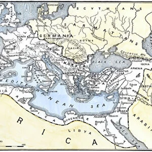
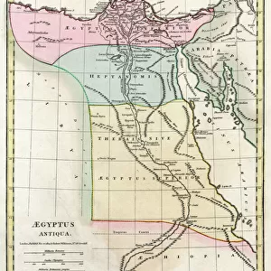
Map of Ancient Egypt

![]()
Wall Art and Photo Gifts from Mary Evans Picture Library
Map of Ancient Egypt
Map of Ancient Egypt. Date: 1814
Mary Evans Picture Library makes available wonderful images created for people to enjoy over the centuries
Media ID 11575345
© Mary Evans / Grenville Collins Postcard Collection
1814 Arabia Arabian Cancer Chart Delta Ethiopia Inferior Maps Mediterranean Nile Superior Tropic
FEATURES IN THESE COLLECTIONS
> Africa
> Egypt
> Related Images
> Africa
> Ethiopia (Abyssinia)
> Related Images
> Africa
> Ethiopia
> Related Images
> Africa
> Related Images
> Arts
> Landscape paintings
> Waterfall and river artworks
> River artworks
> Maps and Charts
> Early Maps
> Maps and Charts
> Related Images
EDITORS COMMENTS
This map, created in 1814, offers a glimpse into the ancient world of Egypt, a land rich in history and culture that continues to fascinate scholars and travelers alike. The map, titled "A New and Correct Chart of Egypt and Nubia," was produced during the classical era of Egyptology, a time when European interest in the ancient civilization was at its peak. The map's intricate details reveal the vast expanse of Egypt, stretching from the First Cataract of the Nile in the south to the Delta region in the north, and from the Mediterranean Sea in the north to the Red Sea and the borders of Arabia in the east. The mighty Nile River, the lifeblood of ancient Egypt, snakes its way through the heart of the country, providing a vital transportation route and irrigating the fertile lands along its banks. The map also highlights the important cities and landmarks of ancient Egypt, including Memphis, Thebes, and Alexandria, as well as the two cataracts that marked the dividing line between the Upper and Lower Kingdoms: the First Cataract, located near Aswan, and the Second Cataract, near Khartoum. The map also indicates the locations of the Tropic of Cancer and the two Niles: the White Nile, which originates in Lake Victoria in present-day Uganda, and the Blue Nile, which originates in Ethiopia. This map, with its meticulous attention to detail and historical accuracy, provides a valuable window into the ancient world of Egypt, a world that continues to captivate and inspire us with its rich history and cultural heritage.
MADE IN THE USA
Safe Shipping with 30 Day Money Back Guarantee
FREE PERSONALISATION*
We are proud to offer a range of customisation features including Personalised Captions, Color Filters and Picture Zoom Tools
SECURE PAYMENTS
We happily accept a wide range of payment options so you can pay for the things you need in the way that is most convenient for you
* Options may vary by product and licensing agreement. Zoomed Pictures can be adjusted in the Cart.