Home > Europe > France > Canton > Landes
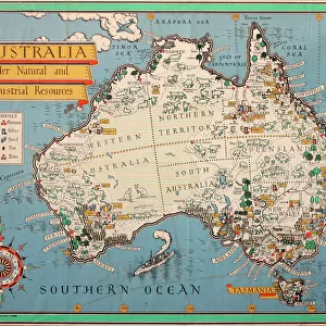
Australia Circa 1760. Mercator Projection. From Atlas De Toutes Les Parties Connues Du Globe Terrestre By Cartographer Rigobert Bonne Published Geneva Circa 1760

![]()
Wall Art and Photo Gifts from Design Pics
Australia Circa 1760. Mercator Projection. From Atlas De Toutes Les Parties Connues Du Globe Terrestre By Cartographer Rigobert Bonne Published Geneva Circa 1760
Design Pics offers Distinctively Different Imagery representing over 1,500 contributors
Media ID 18196280
© Ken Welsh / Design Pics
18th Australia Bonne Cartography Circa Eighteenth Holland Joined Land Making Projection Tasmania Diemens Mercator
FEATURES IN THESE COLLECTIONS
> Europe
> France
> Canton
> Landes
> Maps and Charts
> Early Maps
> Maps and Charts
> Related Images
> Oceania
> Australia
> Related Images
EDITORS COMMENTS
This print takes us back in time to Australia circa 1760, showcasing a Mercator Projection map from the renowned Atlas De Toutes Les Parties Connues Du Globe Terrestre by cartographer Rigobert Bonne. Published in Geneva during the same period, this exquisite piece of cartography offers a glimpse into the historical significance and artistry of map-making in the eighteenth century. The intricate details on this map highlight various regions including New Holland (now known as Australia), Tasmania (formerly Van Diemen's Land), and other significant areas. The Mercator Projection used here allows for accurate representation of landmasses, making it an invaluable tool for explorers and navigators during that era. As we admire this remarkable print, we are transported to a time when exploration was at its peak, and discoveries were being made across uncharted territories. It serves as a reminder of how far our understanding of geography has come since then. Ken Welsh's expertise shines through in capturing every nuance and detail of this historical artifact. Through his lens, we can appreciate not only the scientific value but also the artistic beauty inherent in these early maps. This print is truly a testament to both human curiosity and ingenuity throughout history.
MADE IN THE USA
Safe Shipping with 30 Day Money Back Guarantee
FREE PERSONALISATION*
We are proud to offer a range of customisation features including Personalised Captions, Color Filters and Picture Zoom Tools
SECURE PAYMENTS
We happily accept a wide range of payment options so you can pay for the things you need in the way that is most convenient for you
* Options may vary by product and licensing agreement. Zoomed Pictures can be adjusted in the Cart.