Home > Africa > Sudan > Maps
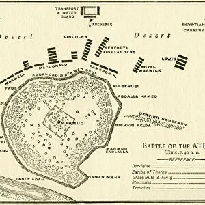
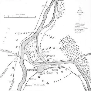
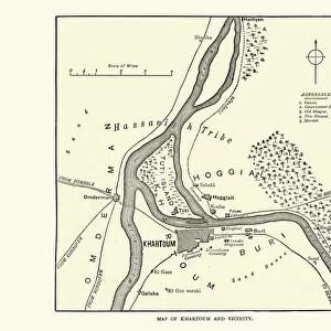
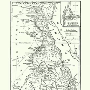
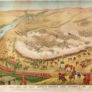
Map Of The Battle Of Omdurman, Khartoum, Sudan, 1898, Showing The 1st Attack At 6. 45 A. m. And The Khalifas Attack At 9. 40 A. m. From Field Marshal Lord Kitchener, His Life And Work For The Empire, Published 1916

![]()
Wall Art and Photo Gifts from Design Pics
Map Of The Battle Of Omdurman, Khartoum, Sudan, 1898, Showing The 1st Attack At 6. 45 A. m. And The Khalifas Attack At 9. 40 A. m. From Field Marshal Lord Kitchener, His Life And Work For The Empire, Published 1916
Map Of The Battle Of Omdurman, Khartoum, Sudan, 1898, Showing The 1st Attack At 6.45 A.m. And The Khalifas Attack At 9.40 A.m. From Field Marshal Lord Kitchener, His Life And Work For The Empire, Published 1916
Design Pics offers Distinctively Different Imagery representing over 1,500 contributors
Media ID 18199747
© Ken Welsh / Design Pics
1898 Anglo Attack Battle Revolt Showing Sudan Sudanese Anglo Sudan War Khalifas Khartoum Mahdist Mahdist Revolt Mahdist War Omdurman
FEATURES IN THESE COLLECTIONS
> Africa
> Sudan
> Related Images
> Historic
> Battles
> Related Images
> Maps and Charts
> Related Images
EDITORS COMMENTS
This print showcases a historically significant moment in the Battle of Omdurman, Khartoum, Sudan in 1898. The detailed map depicts two crucial attacks during the conflict: the first attack at 6.45 a. m. , followed by the Khalifas' attack at 9.40 a. m. This remarkable piece is sourced from "Field Marshal Lord Kitchener, His Life And Work For The Empire" published in 1916. The Battle of Omdurman was part of the larger Mahdist War and marked a turning point in Anglo-Sudanese relations. It was fought between British-Egyptian forces led by General Horatio Herbert Kitchener and Sudanese Mahdist rebels under Khalifa Abdullahi ibn Muhammad's leadership. As you study this map, you can imagine the intensity and strategic planning that went into these attacks as both sides vied for control over Khartoum. The intricate details provide insight into how military tactics were employed during this era. Ken Welsh's expertly captured print allows us to delve into history and understand the complexities of this pivotal battle better. It serves as a reminder of Lord Kitchener's contributions to his empire and sheds light on an important chapter in Sudanese history
MADE IN THE USA
Safe Shipping with 30 Day Money Back Guarantee
FREE PERSONALISATION*
We are proud to offer a range of customisation features including Personalised Captions, Color Filters and Picture Zoom Tools
SECURE PAYMENTS
We happily accept a wide range of payment options so you can pay for the things you need in the way that is most convenient for you
* Options may vary by product and licensing agreement. Zoomed Pictures can be adjusted in the Cart.