Home > Maps and Charts > Early Maps
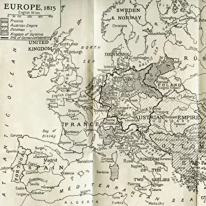
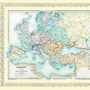
Map of Europe in 1815. From The Evolution of Modern Europe, 1453 - 1932, published 1933

![]()
Wall Art and Photo Gifts from Design Pics
Map of Europe in 1815. From The Evolution of Modern Europe, 1453 - 1932, published 1933
Design Pics offers Distinctively Different Imagery representing over 1,500 contributors
Media ID 24905982
© Ken Welsh
Countries Geographical Geography Maps 1815
FEATURES IN THESE COLLECTIONS
> Maps and Charts
> Early Maps
> Maps and Charts
> Related Images
EDITORS COMMENTS
This print showcases a remarkable piece of history - the Map of Europe in 1815. Taken from the renowned book "The Evolution of Modern Europe, 1453 - 1932" published in 1933 by Ken Welsh, this archival treasure offers a glimpse into the intricate geopolitical landscape of early 19th-century Europe. With its meticulous detail and stunning illustration, this map takes us back to a time when borders were vastly different than they are today. It serves as a testament to the ever-changing nature of our world and provides valuable insights into European geography during that era. Each country is clearly demarcated, allowing us to trace their boundaries and observe how nations have evolved over time. This historical gem not only appeals to cartography enthusiasts but also invites anyone with an interest in European history or geography to explore its rich tapestry. As we gaze upon this vintage masterpiece, we can't help but marvel at the craftsmanship and dedication required to create such an intricate representation. The faded hues lend an air of nostalgia while reminding us that these lines on paper once held immense significance for millions living within them. Whether you're fascinated by maps or simply appreciate glimpses into our past, this print transports you back in time and immerses you in the fascinating world of early modern Europe.
MADE IN THE USA
Safe Shipping with 30 Day Money Back Guarantee
FREE PERSONALISATION*
We are proud to offer a range of customisation features including Personalised Captions, Color Filters and Picture Zoom Tools
SECURE PAYMENTS
We happily accept a wide range of payment options so you can pay for the things you need in the way that is most convenient for you
* Options may vary by product and licensing agreement. Zoomed Pictures can be adjusted in the Cart.