Home > Arts > Landscape paintings > Waterfall and river artworks > River artworks
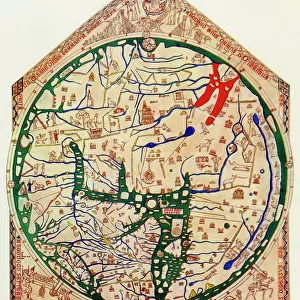
Map Of The Nile Basin In 1819 Ad. From In Darkest Africa By Henry M. Stanley Published 1890

![]()
Wall Art and Photo Gifts from Design Pics
Map Of The Nile Basin In 1819 Ad. From In Darkest Africa By Henry M. Stanley Published 1890
Design Pics offers Distinctively Different Imagery representing over 1,500 contributors
Media ID 18196455
© Ken Welsh / Design Pics
Africa African Basin Chart Exploration Geography Mapmaking Nile Nineteenth
FEATURES IN THESE COLLECTIONS
> Africa
> Related Images
> Arts
> Landscape paintings
> Waterfall and river artworks
> River artworks
> Maps and Charts
> Related Images
EDITORS COMMENTS
This print showcases a historical treasure - the Map of the Nile Basin in 1819 AD. From renowned explorer Henry M. Stanley's book "In Darkest Africa" published in 1890, this map offers a fascinating glimpse into the geography and exploration of Africa during the nineteenth century. The intricate details on this map transport us back to an era when charting unexplored territories was both a scientific endeavor and an adventurous pursuit. As we study its lines and contours, we can almost feel the excitement that must have filled explorers' hearts as they ventured into unknown lands. The Nile River takes center stage, winding its way through vast stretches of African terrain. Its significance as one of the world's longest rivers cannot be overstated, serving as a lifeline for countless civilizations throughout history. With every stroke meticulously crafted by cartographers from centuries past, this map is not just a visual representation but also a testament to human curiosity and ingenuity. It reminds us of our innate desire to understand our surroundings and unravel nature's mysteries. Ken Welsh has skillfully captured this piece of history with his expert photography skills, allowing us to appreciate its beauty and significance even today. This print serves as both an educational tool for those interested in African geography and exploration enthusiasts who seek to delve deeper into the rich tapestry of our planet's past.
MADE IN THE USA
Safe Shipping with 30 Day Money Back Guarantee
FREE PERSONALISATION*
We are proud to offer a range of customisation features including Personalised Captions, Color Filters and Picture Zoom Tools
SECURE PAYMENTS
We happily accept a wide range of payment options so you can pay for the things you need in the way that is most convenient for you
* Options may vary by product and licensing agreement. Zoomed Pictures can be adjusted in the Cart.