Home > South America > Peru > Maps
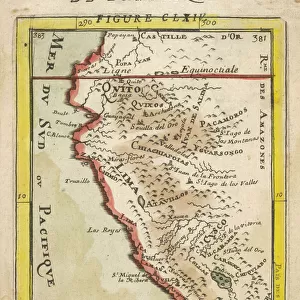
Map Of Peru, Circa. 1760. From "Atlas De Toutes Les Parties Connues Du Globe Terrestre "By Cartographer Rigobert Bonne. Published Geneva Circa. 1760

![]()
Wall Art and Photo Gifts from Design Pics
Map Of Peru, Circa. 1760. From "Atlas De Toutes Les Parties Connues Du Globe Terrestre "By Cartographer Rigobert Bonne. Published Geneva Circa. 1760
Map Of Peru, Circa.1760. From " Atlas De Toutes Les Parties Connues Du Globe Terrestre " By Cartographer Rigobert Bonne. Published Geneva Circa. 1760
Design Pics offers Distinctively Different Imagery representing over 1,500 contributors
Media ID 18186455
© Ken Welsh / Design Pics
Cartography Geography Mapmaking Peru Plate
FEATURES IN THESE COLLECTIONS
> Maps and Charts
> Related Images
> South America
> Peru
> Maps
> South America
> Peru
> Related Images
EDITORS COMMENTS
This print showcases a remarkable piece of history - the Map of Peru, circa 1760. Created by renowned cartographer Rigobert Bonne and published in Geneva during the same period, this map is an exquisite example of his exceptional craftsmanship. With its vibrant colors and intricate engravings, this map offers a fascinating glimpse into the geography and topography of Peru during the 18th century. Every detail has been meticulously captured, from the sprawling mountain ranges to the winding rivers that traverse through this enchanting land. As you explore this vertical plate illustration, you will be transported back in time to an era when mapmaking was both an art form and a scientific endeavor. The precision with which Bonne crafted each element reflects his dedication to accuracy and his passion for showcasing the world's wonders. Whether you are a history enthusiast or simply appreciate fine craftsmanship, this print is sure to captivate your imagination. Display it proudly in your home or office as a testament to human curiosity and our never-ending quest for knowledge about our planet's diverse landscapes. Ken Welsh's expert photography skillfully captures every nuance of color and detail on this stunning map print. Add it to your collection today and embark on a visual journey through time as you immerse yourself in Peru's rich cartographic heritage.
MADE IN THE USA
Safe Shipping with 30 Day Money Back Guarantee
FREE PERSONALISATION*
We are proud to offer a range of customisation features including Personalised Captions, Color Filters and Picture Zoom Tools
SECURE PAYMENTS
We happily accept a wide range of payment options so you can pay for the things you need in the way that is most convenient for you
* Options may vary by product and licensing agreement. Zoomed Pictures can be adjusted in the Cart.