Home > Europe > Russia > Maps
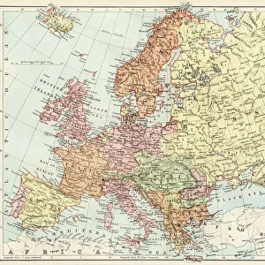
Map Of Russia, Circa. 1760. From "Atlas De Toutes Les Parties Connues Du Globe Terrestre "By Cartographer Rigobert Bonne. Published Geneva Circa. 1760

![]()
Wall Art and Photo Gifts from Design Pics
Map Of Russia, Circa. 1760. From "Atlas De Toutes Les Parties Connues Du Globe Terrestre "By Cartographer Rigobert Bonne. Published Geneva Circa. 1760
Map Of Russia, Circa.1760. From " Atlas De Toutes Les Parties Connues Du Globe Terrestre " By Cartographer Rigobert Bonne. Published Geneva Circa. 1760
Design Pics offers Distinctively Different Imagery representing over 1,500 contributors
Media ID 18186425
© Ken Welsh / Design Pics
Cartography Geography Mapmaking Plate Russia
FEATURES IN THESE COLLECTIONS
> Europe
> Russia
> Related Images
> Maps and Charts
> Related Images
EDITORS COMMENTS
This print showcases a beautifully detailed map of Russia, dating back to the year 1760. Taken from the renowned "Atlas De Toutes Les Parties Connues Du Globe Terrestre" by esteemed cartographer Rigobert Bonne, this piece offers a fascinating glimpse into the geography and history of Russia during that era. The map is rich in color and intricately engraved, capturing every minute detail with precision. The horizontal layout allows for easy navigation across its expansive territory, while the vibrant hues bring life to each region depicted. It serves as a testament to Bonne's mastery in mapmaking and his dedication to accurately representing the world. Published in Geneva circa 1760, this historical artifact holds immense value for both cartography enthusiasts and those interested in Russian history. Its significance lies not only in its artistic beauty but also as a valuable resource for understanding how perceptions of geography have evolved over time. Ken Welsh has skillfully captured this remarkable piece through his lens, preserving its essence for future generations to appreciate. This print invites viewers on an immersive journey through time and space, offering a window into Russia's past like never before seen.
MADE IN THE USA
Safe Shipping with 30 Day Money Back Guarantee
FREE PERSONALISATION*
We are proud to offer a range of customisation features including Personalised Captions, Color Filters and Picture Zoom Tools
SECURE PAYMENTS
We happily accept a wide range of payment options so you can pay for the things you need in the way that is most convenient for you
* Options may vary by product and licensing agreement. Zoomed Pictures can be adjusted in the Cart.