Home > Africa > Egypt > Maps
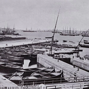
Plan Of Alexandria, Egypt At The Turn Of The 20Th Century. Map Is Edited In Spanish Language. From Enciclopedia Ilustrada Segu

![]()
Wall Art and Photo Gifts from Design Pics
Plan Of Alexandria, Egypt At The Turn Of The 20Th Century. Map Is Edited In Spanish Language. From Enciclopedia Ilustrada Segu
Design Pics offers Distinctively Different Imagery representing over 1,500 contributors
Media ID 18198181
© Ken Welsh / Design Pics
20th Alexandria City Egypt Egyptian Harbor Harbour Layout Plan Port Turn Twentieth Nineteenth
FEATURES IN THESE COLLECTIONS
> Africa
> Egypt
> Alexandria
> Africa
> Egypt
> Related Images
> Europe
> Spain
> Related Images
> Maps and Charts
> Related Images
> Maps and Charts
> Spain
EDITORS COMMENTS
This print showcases a detailed map of Alexandria, Egypt at the turn of the 20th century. The map is uniquely edited in the Spanish language, adding an intriguing element to this historical piece. From Enciclopedia Ilustrada Segu, this print offers a glimpse into the rich history and cultural exchange between Spain and Egypt during that era. The layout of the Egyptian city is meticulously depicted, highlighting its strategic location as a bustling port and harbor on the Mediterranean Sea. The intricate details capture both the grandeur and complexity of Alexandria's urban landscape. As we delve into this image, we are transported back to a time when Alexandria was experiencing significant growth and transformation at the end of the 19th century. This period marked a turning point for not only Egypt but also for global trade and exploration. Ken Welsh's masterful composition allows us to appreciate how cities evolve over time while preserving their unique heritage. Through his lens, we can almost hear echoes from centuries past - whispers of ancient civilizations blending with modern advancements. Whether you are an avid historian or simply captivated by maps that tell stories, this print invites you to explore Alexandria's vibrant past through its streets, buildings, and landmarks. It serves as a reminder that our world is interconnected across continents and languages – bridging cultures through shared knowledge and curiosity about our collective history.
MADE IN THE USA
Safe Shipping with 30 Day Money Back Guarantee
FREE PERSONALISATION*
We are proud to offer a range of customisation features including Personalised Captions, Color Filters and Picture Zoom Tools
SECURE PAYMENTS
We happily accept a wide range of payment options so you can pay for the things you need in the way that is most convenient for you
* Options may vary by product and licensing agreement. Zoomed Pictures can be adjusted in the Cart.