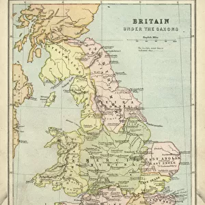
Home > Europe > United Kingdom > England > London > Boroughs > City of London
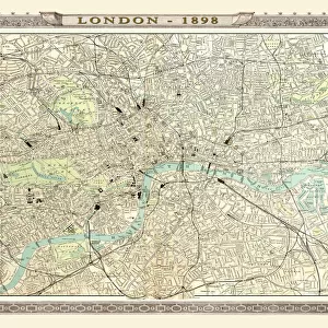
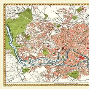
Old Map of Central London 1898 from the Royal Atlas by Bartholomew

![]()
Wall Art and Photo Gifts from MapSeeker
Old Map of Central London 1898 from the Royal Atlas by Bartholomew
A fine very detailed plan of Central London from 1898 remastered from an original contained within " The Royal Atlas of England and Wales" ; edited by J.G. Bartholomew, published by George Newnes, Limited, London
Welcome to the Mapseeker Image library and enter an historic gateway to one of the largest on-line collections of Historic Maps, Nostalgic Views, Vista's and Panorama's from a World gone by.
Media ID 20347628
Bartholomew Bartholomew Map Historic Map London Map Map Of Central London Map Of London Old Town Plan Royal Atlas Royal Atlas Map Central London London City
FEATURES IN THESE COLLECTIONS
> Arts
> Photorealistic artworks
> Detailed art pieces
> Masterful detailing in art
> Europe
> United Kingdom
> England
> London
> Boroughs
> City of London
> Europe
> United Kingdom
> England
> London
> Royalty
> Europe
> United Kingdom
> England
> Maps
> Europe
> United Kingdom
> Wales
> Maps
> Europe
> United Kingdom
> Wales
> Posters
> Maps and Charts
> Related Images
> Maps and Charts
> Wales
> MapSeeker
> British Town And City Plans
> English & Welsh PORTFOLIO
EDITORS COMMENTS
Step back in time with this remarkable print of an 'Old Map of Central London 1898' from the prestigious Royal Atlas by Bartholomew. This fine and highly detailed plan offers a captivating glimpse into the bustling streets and landmarks of Victorian-era London. Remastered from an original map found within 'The Royal Atlas of England and Wales, ' edited by J. G. Bartholomew, and published by George Newnes, Limited in London, this print showcases the intricate craftsmanship that went into cartography during that era. Every street, square, park, and building is meticulously depicted on this historic map. It allows you to trace the evolution of one of the world's most iconic cities as it stood over a century ago. Immerse yourself in the past as you explore familiar areas such as Covent Garden, Westminster Abbey, or St Paul's Cathedral through their earlier architectural forms. Whether you are a history enthusiast or simply fascinated by urban development, this old town plan provides a unique perspective on Central London's rich heritage. Display it proudly in your home or office to spark conversations about how our beloved city has transformed throughout time
MADE IN THE USA
Safe Shipping with 30 Day Money Back Guarantee
FREE PERSONALISATION*
We are proud to offer a range of customisation features including Personalised Captions, Color Filters and Picture Zoom Tools
SECURE PAYMENTS
We happily accept a wide range of payment options so you can pay for the things you need in the way that is most convenient for you
* Options may vary by product and licensing agreement. Zoomed Pictures can be adjusted in the Cart.