Home > Europe > United Kingdom > England > London > Museums > British Library
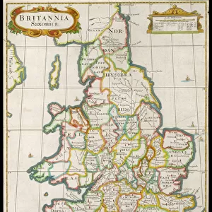
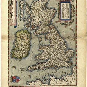
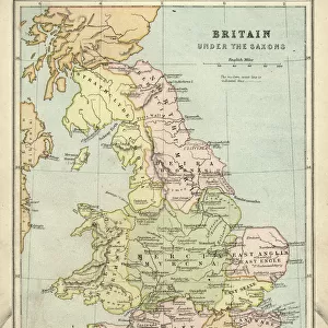
Matthew Pariss Map of Great Britain showing rivers & towns in the south of England & part of Wales, c. 1250 (1944)
")
![]()
Wall Art and Photo Gifts from Heritage Images
Matthew Pariss Map of Great Britain showing rivers & towns in the south of England & part of Wales, c. 1250 (1944)
Many place-names are still recognisable today. The word Auster, written over the English Channel at the bottom, refers to wind bringing heavy cloud cover and fog. Map drawn by the historian Matthew Paris, a monk at St Albans Abbey. Cotton MS Claudius D.vi, f.12v, manuscript in the British Library, London. From " British Maps and Map-Makers", by Edward Lynam. [Collins, London, 1944]
Heritage Images features heritage image collections
Media ID 19777528
© The Print Collector/Heritage Images
Britain In Pictures Channel Coastline Collins Cornwall Dorset East Anglia Edward Edward Lynam English Channel Lynam Matthew Rivers Social History Wales William Collins William Collins And Sons William Collins Sons Wind Windy Graphic Design Matthew Paris Thirteenth Century West Country
FEATURES IN THESE COLLECTIONS
> Animals
> Mammals
> Muridae
> Fortior
> Arts
> Art Movements
> Medieval Art
> Arts
> Artists
> C
> William Collins
> Europe
> France
> Paris
> Maps
> Europe
> United Kingdom
> England
> Cornwall
> Related Images
> Europe
> United Kingdom
> England
> Dorset
> Related Images
> Europe
> United Kingdom
> England
> London
> Museums
> British Library
> Europe
> United Kingdom
> England
> London
> Weather
> Europe
> United Kingdom
> England
> Maps
> Europe
> United Kingdom
> England
> Rivers
EDITORS COMMENTS
This print showcases Matthew Paris' Map of Great Britain, offering a glimpse into the country's geography and history during the 13th century. Created around 1250, this medieval masterpiece reveals rivers, towns, and even weather patterns in the southern region of England and parts of Wales. The map's intricate design and vivid colors draw attention to its meticulous details. As we examine this historical artifact, it becomes apparent that many place-names depicted on the map are still recognizable today, demonstrating how some locations have retained their identity over centuries. Notably, the word "Auster" is inscribed over the English Channel at the bottom of the map, signifying wind patterns associated with heavy cloud cover and fog. Matthew Paris himself was a historian and monk at St Albans Abbey who dedicated his talents to cartography. This particular manuscript is preserved in London's British Library as Cotton MS Claudius D. vi. Its inclusion in Edward Lynam's book "British Maps and Map-Makers" further solidifies its significance within cartographic studies. The print allows us to appreciate both the artistic beauty of this medieval map as well as its valuable insights into Britain's social history. It serves as a reminder of our rich heritage while highlighting how geographical features have shaped our understanding of different regions throughout time.
MADE IN THE USA
Safe Shipping with 30 Day Money Back Guarantee
FREE PERSONALISATION*
We are proud to offer a range of customisation features including Personalised Captions, Color Filters and Picture Zoom Tools
SECURE PAYMENTS
We happily accept a wide range of payment options so you can pay for the things you need in the way that is most convenient for you
* Options may vary by product and licensing agreement. Zoomed Pictures can be adjusted in the Cart.