Home > Animals > Mammals > Muridae > Western Mouse
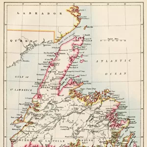
Map Of Western Canada Including The Five Great Lakes, Circa 1760. From Atlas De Toutes Les Parties Connues Du Globe Terrestre By Cartographer Rigobert Bonne Published Geneva Circa 1760

![]()
Wall Art and Photo Gifts from Design Pics
Map Of Western Canada Including The Five Great Lakes, Circa 1760. From Atlas De Toutes Les Parties Connues Du Globe Terrestre By Cartographer Rigobert Bonne Published Geneva Circa 1760
Design Pics offers Distinctively Different Imagery representing over 1,500 contributors
Media ID 18196357
© Ken Welsh / Design Pics
18th Bonne Canadian Cartography Circa Continent Eighteenth Geographical Geography Great Lakes Making North Western
FEATURES IN THESE COLLECTIONS
> Animals
> Mammals
> Muridae
> Western Mouse
> Maps and Charts
> Early Maps
> Maps and Charts
> Related Images
> North America
> Canada
> Lakes
> Related Images
> North America
> Canada
> Maps
> North America
> Canada
> Related Images
> North America
> Related Images
EDITORS COMMENTS
This print showcases a historically significant map of Western Canada, including the Five Great Lakes, dating back to circa 1760. The intricate details and artistry of this map are truly remarkable, offering a glimpse into the geographical understanding and cartographic skills of the time. Created by renowned cartographer Rigobert Bonne and published in Geneva during the eighteenth century, this map is part of his esteemed work titled "Atlas De Toutes Les Parties Connues Du Globe Terrestre". It serves as a testament to Bonne's dedication to accurately representing the world through his maps. The Map of Western Canada Including The Five Great Lakes provides valuable insights into North American history and geography during that era. It allows us to trace the development and exploration of this vast continent while highlighting key landmarks such as lakes Superior, Michigan, Huron, Erie, and Ontario. As we admire this piece from Ken Welsh's collection at Design Pics, we can't help but appreciate its significance in preserving our historical heritage. This illustration not only offers an educational resource for those interested in Canadian history but also serves as a reminder of how far cartography has come since the 18th century. Whether you're fascinated by historical maps or simply intrigued by Western Canada's rich past, this print is sure to captivate your imagination with its blend of artistry and geographical accuracy.
MADE IN THE USA
Safe Shipping with 30 Day Money Back Guarantee
FREE PERSONALISATION*
We are proud to offer a range of customisation features including Personalised Captions, Color Filters and Picture Zoom Tools
SECURE PAYMENTS
We happily accept a wide range of payment options so you can pay for the things you need in the way that is most convenient for you
* Options may vary by product and licensing agreement. Zoomed Pictures can be adjusted in the Cart.