Home > Europe > United Kingdom > Scotland > Edinburgh > Edinburgh
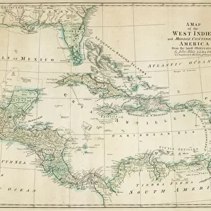
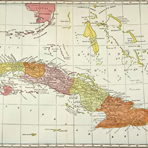
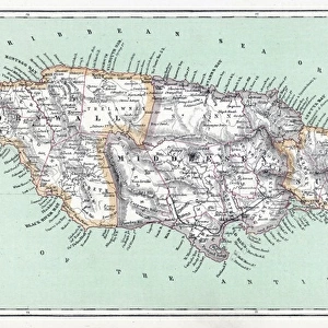
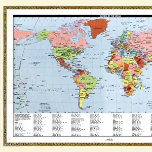
Map of the West Indies and Central America, 1902. Creator: Unknown

![]()
Wall Art and Photo Gifts from Heritage Images
Map of the West Indies and Central America, 1902. Creator: Unknown
Map of the West Indies and Central America, 1902. Showing the various Caribbean islands, and the north coast of South America. From The Century Atlas of the World. [John Walker & Co, Ltd. London, 1902]
Heritage Images features heritage image collections
Media ID 15512446
© The Print Collector / Heritage-Images
Caribbean Central America Cuba Edinburgh Geographical Institute Haiti Indies Jamaica Nicaragua West Indies
FEATURES IN THESE COLLECTIONS
> Europe
> United Kingdom
> Scotland
> Edinburgh
> Edinburgh
> Europe
> United Kingdom
> Scotland
> Lothian
> Edinburgh
> Maps and Charts
> Related Images
> Maps and Charts
> World
> North America
> Cuba
> Maps
> North America
> Cuba
> Related Images
> North America
> Haiti
> Maps
> North America
> Haiti
> Related Images
> North America
> Jamaica
> Maps
EDITORS COMMENTS
This print showcases a Map of the West Indies and Central America from 1902, created by an unknown artist. The map offers a glimpse into the intricate geography of this enchanting region, featuring the Caribbean islands and the northern coast of South America. With its vibrant colors and detailed illustrations, it captures the essence of early 20th-century cartography. The map highlights various countries including Cuba, Haiti, Jamaica, Nicaragua, and many more. Each geographical feature is meticulously depicted to provide an accurate representation of these lands. Created for The Century Atlas of the World by John Walker & Co in London in 1902, this print serves as a valuable historical artifact. As we delve into this visual treasure trove crafted by Edinburgh Geographical Institute, we are transported back in time to an era when exploration was at its peak. It reminds us of the allure that once surrounded these tropical destinations - their pristine beaches lapped by crystal-clear seas. Preserved with care by The Print Collector and now made available for all to admire through Heritage Images' collection, this map invites us to explore not only physical locations but also our own curiosity about history and culture. It is a testament to human ingenuity in unraveling nature's secrets while simultaneously serving as a reminder that there is still so much left undiscovered on our planet Earth.
MADE IN THE USA
Safe Shipping with 30 Day Money Back Guarantee
FREE PERSONALISATION*
We are proud to offer a range of customisation features including Personalised Captions, Color Filters and Picture Zoom Tools
SECURE PAYMENTS
We happily accept a wide range of payment options so you can pay for the things you need in the way that is most convenient for you
* Options may vary by product and licensing agreement. Zoomed Pictures can be adjusted in the Cart.