Home > Europe > Germany > Maps
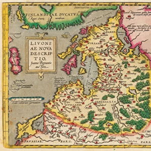
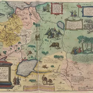
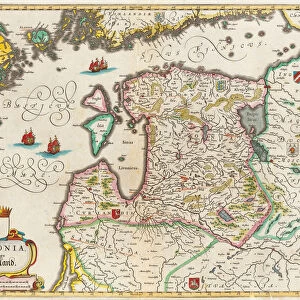
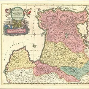
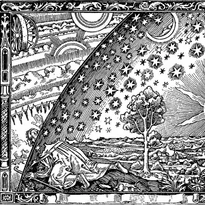
The Baltic Sea (From: Baltikum Ducatuum Livoniae et Curlandiae cum vicinis Insulis Nova Exhibitio Geographica), ca 1720. Artist: Homann, Johann Baptist (1663-1724)
, ca 1720. Artist: Homann, Johann Baptist (1663-1724)")
![]()
Wall Art and Photo Gifts from Heritage Images
The Baltic Sea (From: Baltikum Ducatuum Livoniae et Curlandiae cum vicinis Insulis Nova Exhibitio Geographica), ca 1720. Artist: Homann, Johann Baptist (1663-1724)
The Baltic Sea (From: Baltikum Ducatuum Livoniae et Curlandiae cum vicinis Insulis Nova Exhibitio Geographica), ca 1720. From a private collection
Heritage Images features heritage image collections
Media ID 14896398
© Fine Art Images
Baltic Sea Cartography Courland Homann Johann Baptist 1663 1724 Livonia Copper Engraving Sea Map
FEATURES IN THESE COLLECTIONS
> Arts
> Artists
> Related Images
EDITORS COMMENTS
This print showcases "The Baltic Sea" as depicted in the map titled "Baltikum Ducatuum Livoniae et Curlandiae cum vicinis Insulis Nova Exhibitio Geographica" created around 1720 by the talented artist Johann Baptist Homann (1663-1724). The image, sourced from a private collection, offers a glimpse into the rich history and fine art of cartography. Homann's copper engraving beautifully captures the intricate details of this important sea. The watercolor elements add depth and vibrancy to the map, making it an exquisite piece of graphic art. As one explores this historical artifact, they are transported back in time to witness how these regions were perceived during that era. The map encompasses Germany's coastline along with Livonia and Courland, providing valuable geographical information about neighboring islands as well. It serves not only as a navigational tool but also as a testament to the advancements made in mapping techniques during Homann's time. This print is more than just an artistic representation; it is a window into our past. It allows us to appreciate both the beauty of nature and human ingenuity through cartography. Whether you are fascinated by history or simply drawn to its aesthetic appeal, this image will undoubtedly captivate your imagination with its intricate details and evocative colors.
MADE IN THE USA
Safe Shipping with 30 Day Money Back Guarantee
FREE PERSONALISATION*
We are proud to offer a range of customisation features including Personalised Captions, Color Filters and Picture Zoom Tools
SECURE PAYMENTS
We happily accept a wide range of payment options so you can pay for the things you need in the way that is most convenient for you
* Options may vary by product and licensing agreement. Zoomed Pictures can be adjusted in the Cart.