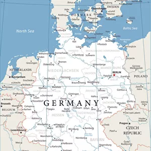
Home > Europe > Germany > Maps
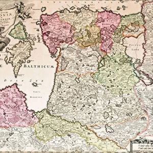
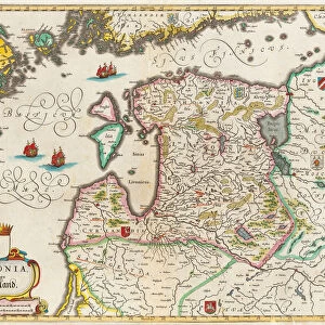
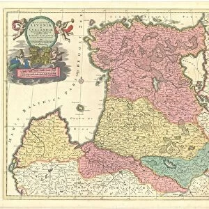
Livonia Map, Livoniae Nova Descriptio, 1573-1578. Artist: Anonymous master

![]()
Wall Art and Photo Gifts from Heritage Images
Livonia Map, Livoniae Nova Descriptio, 1573-1578. Artist: Anonymous master
Livonia Map, Livoniae Nova Descriptio, 1573-1578. From a private collection
Heritage Images features heritage image collections
Media ID 14856583
© Fine Art Images
Anonymous Master Baltic Sea Cartography Courland Livonia Sea Map
FEATURES IN THESE COLLECTIONS
> Arts
> Artists
> Related Images
EDITORS COMMENTS
This print showcases the exquisite Livonia Map, titled "Livoniae Nova Descriptio" created between 1573 and 1578 by an anonymous master. The map, originating from a private collection, offers a fascinating glimpse into the rich history of Germany and its neighboring regions. The intricate woodcut design combined with delicate watercolor details make this piece a true masterpiece of cartography and graphic arts. As we gaze upon it, we are transported back in time to an era when maps were not only functional but also works of fine art. The Livonia Map provides valuable insights into the Baltic Sea region's geography during the late 16th century. Its meticulous depiction includes various cities, rivers, forests, and coastlines that once shaped the historical landscape of Livonia and Courland. Though its creator remains unknown to us today, their skillful craftsmanship is evident in every stroke. This artwork serves as a testament to their talent and dedication to preserving geographical knowledge for future generations. As we admire this remarkable sea map from centuries ago, let us appreciate both its aesthetic beauty and historical significance. It stands as a reminder of how art can transcend time and continue to captivate our imaginations while offering glimpses into our past.
MADE IN THE USA
Safe Shipping with 30 Day Money Back Guarantee
FREE PERSONALISATION*
We are proud to offer a range of customisation features including Personalised Captions, Color Filters and Picture Zoom Tools
SECURE PAYMENTS
We happily accept a wide range of payment options so you can pay for the things you need in the way that is most convenient for you
* Options may vary by product and licensing agreement. Zoomed Pictures can be adjusted in the Cart.