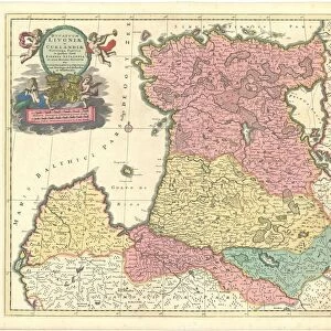
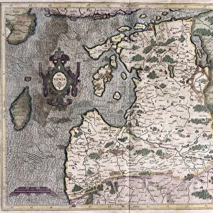
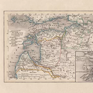
Map Tabula ducatuum Livoniae et Curlandiae recentior incisa editaque

![]()
Wall Art and Photo Gifts from Liszt Collection
Map Tabula ducatuum Livoniae et Curlandiae recentior incisa editaque
Map, Tabula ducatuum Livoniae et Curlandiae recentior incisa editaque per Gerardum Valck, Gerhard Valk (-1726), Copperplate print
Liszt Collection of nineteenth-century engravings and images to browse and enjoy
Media ID 19584914
© Artokoloro
1726 Copperplate Print Gerhard Valk
EDITORS COMMENTS
This print showcases a historical map titled "Map, Tabula ducatuum Livoniae et Curlandiae recentior incisa editaque" by Gerardum Valck, also known as Gerhard Valk. Created in 1726 using copperplate print technique, this exquisite piece of cartography offers a glimpse into the past. The map depicts the territories of Livonia and Courland, providing valuable insights into their geographical boundaries during that era. With intricate details and precise craftsmanship, Valck's work highlights his mastery in capturing the essence of these regions. As we delve into this fascinating image, we are transported back to a time when maps were not just navigational tools but works of art themselves. The delicate lines and ornate embellishments on this copperplate print reveal the dedication and skill required to create such an impressive piece. Through its rich colors and meticulous design, this print allows us to appreciate the historical significance of Livonia and Courland while marveling at Valck's artistic prowess. It serves as a reminder that maps hold stories within them – tales of exploration, conquests, and cultural heritage. Whether displayed in a study or gallery setting, this print from Liszt Collection is sure to captivate viewers with its blend of history and artistry. A true testament to human curiosity and creativity throughout centuries!
MADE IN THE USA
Safe Shipping with 30 Day Money Back Guarantee
FREE PERSONALISATION*
We are proud to offer a range of customisation features including Personalised Captions, Color Filters and Picture Zoom Tools
SECURE PAYMENTS
We happily accept a wide range of payment options so you can pay for the things you need in the way that is most convenient for you
* Options may vary by product and licensing agreement. Zoomed Pictures can be adjusted in the Cart.