Home > Arts > Artists > T > John Tallis
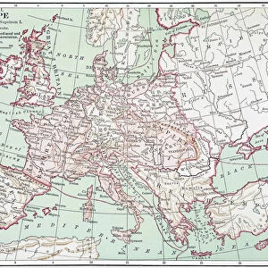
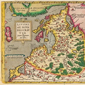
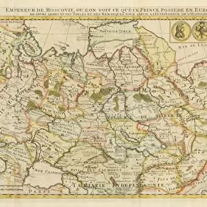
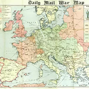
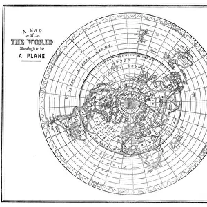
Russia in Europe 1851

![]()
Wall Art and Photo Gifts from MapSeeker
Russia in Europe 1851
A fine facimile artworked from an antique original map of Russia in Europe, issued as part of the 1851 edition of John Tallis and Companys " The Illustrated Atlas and Modern History of the World"
Welcome to the Mapseeker Image library and enter an historic gateway to one of the largest on-line collections of Historic Maps, Nostalgic Views, Vista's and Panorama's from a World gone by.
Media ID 20347523
© Mapseeker Publishing Ltd
John Tallis John Tallis Map Tallis Map
FEATURES IN THESE COLLECTIONS
> Arts
> Artists
> T
> John Tallis
> Europe
> Russia
> Related Images
> Maps and Charts
> Related Images
> Maps and Charts
> World
EDITORS COMMENTS
This print showcases a remarkable piece of cartographic history - a fine facsimile artworked from an antique original map of Russia in Europe, dating back to 1851. This exquisite map was originally issued as part of the renowned 1851 edition of John Tallis and Company's "The Illustrated Atlas and Modern History of the World". With its intricate details and elegant design, this old map offers a fascinating glimpse into the past, allowing us to explore the vast expanse of Russia in Europe during that era. From Moscow to St. Petersburg, from the Baltic Sea to the Black Sea, every city, river, and mountain range is meticulously depicted on this historical gem. Created by esteemed cartographers John Tallis and John Rapkin, this masterpiece reflects their dedication to accuracy and artistry. The delicate lines and vibrant colors bring life to each region while evoking a sense of nostalgia for a bygone era. As we gaze upon this image, we are transported back in time - imagining horse-drawn carriages traversing ancient roads or sailors navigating through uncharted waters. It serves as a testament to human curiosity and our relentless pursuit of knowledge about our world. Whether you are an avid historian or simply appreciate beautiful works of art, this print is sure to captivate your imagination with its rich history and timeless beauty.
MADE IN THE USA
Safe Shipping with 30 Day Money Back Guarantee
FREE PERSONALISATION*
We are proud to offer a range of customisation features including Personalised Captions, Color Filters and Picture Zoom Tools
SECURE PAYMENTS
We happily accept a wide range of payment options so you can pay for the things you need in the way that is most convenient for you
* Options may vary by product and licensing agreement. Zoomed Pictures can be adjusted in the Cart.