Home > Europe > United Kingdom > England > London > Towns > Welling
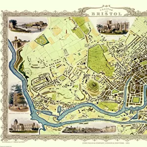
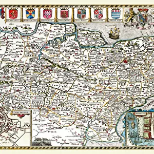
Old Map of the Environs of Bath and Bristol 1836 by Thomas Moule

![]()
Wall Art and Photo Gifts from MapSeeker
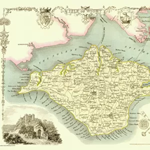
Old Map of the Environs of Bath and Bristol 1836 by Thomas Moule
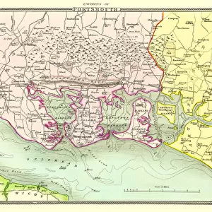
This is a fine decorative reproduction Map of The Environs of Bath and Bristol from the First Edition series of Thomas Moule Maps, originally Published in 1836, with a detailed decorative view of Redcliffe Church.The well-known series of County Maps which are known as Moules feature beautiful vignette views, there were also 4 " Environs" Maps included, and were first published in separate sections for each county in 1830-32, they were then published in collected form in a two-volume work: The English Counties Delineated: or a Topographical Description of England: Illustrated by a Complete Series of County Maps by Thomas Moule: London: Published by George Virtue 1836
Welcome to the Mapseeker Image library and enter an historic gateway to one of the largest on-line collections of Historic Maps, Nostalgic Views, Vista's and Panorama's from a World gone by.
Media ID 20348064
© Mapseeker Publishing Ltd
Historic Map Moule Map Old Moule Map Thomas Moule Thomas Moule Map Bristol
FEATURES IN THESE COLLECTIONS
> Arts
> Artists
> M
> Thomas Moule
> Arts
> Photorealistic artworks
> Detailed art pieces
> Masterful detailing in art
> Europe
> United Kingdom
> England
> Bath
> Europe
> United Kingdom
> England
> Bristol
> Bristol
> Europe
> United Kingdom
> England
> London
> Towns
> Welling
> Europe
> United Kingdom
> England
> Maps
> Europe
> United Kingdom
> England
> Wells
> Maps and Charts
> Related Images
> MapSeeker
> British Town And City Plans
> English & Welsh PORTFOLIO
> MapSeeker
> Maps from the British Isles
> England and Counties PORTFOLIO
EDITORS COMMENTS
This exquisite print showcases an Old Map of the Environs of Bath and Bristol, meticulously crafted by Thomas Moule in 1836. A true gem from the First Edition series of Moule's maps, this decorative reproduction captures the essence of a bygone era. Originally published as part of The English Counties Delineated: or a Topographical Description of England, this map offers a fascinating glimpse into the past. The intricate details on this historic map are truly captivating. From its ornate vignette views to its comprehensive depiction of Redcliffe Church, every element has been thoughtfully rendered. Moule's mastery shines through as he skillfully presents both Bath and Bristol along with their surrounding areas. Moule's County Maps have long been celebrated for their beauty and accuracy, making them highly sought after among collectors and enthusiasts alike. This particular piece is one of four "Environs". Maps included in his renowned collection. With George Virtue as the publisher, this two-volume work became a cherished addition to any cartography lover's library. Now available as a stunning photo print, it allows us to appreciate not only the historical significance but also the artistic brilliance that went into creating such masterpieces. Whether you're drawn to Bristol's rich history or Bath's timeless charm, this old map transports you back in time while adding an elegant touch to any space it graces.
MADE IN THE USA
Safe Shipping with 30 Day Money Back Guarantee
FREE PERSONALISATION*
We are proud to offer a range of customisation features including Personalised Captions, Color Filters and Picture Zoom Tools
SECURE PAYMENTS
We happily accept a wide range of payment options so you can pay for the things you need in the way that is most convenient for you
* Options may vary by product and licensing agreement. Zoomed Pictures can be adjusted in the Cart.