Home > Aerial Photography > America
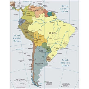
South America, topographic map

![]()
Wall Art and Photo Gifts from Science Photo Library
South America, topographic map
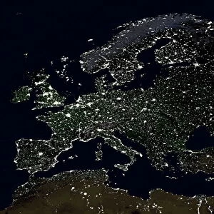
South America, topographic map. Highlands and lowlands of the continents are also shown, as ridges and flat areas. North America and the Caribbean (top left) and Antarctica (bottom right) are also seen, along with the Atlantic Ocean (right) and the Pacific Ocean (left). The seabed depth varies from shallow (light blue) on the continental shelves, to deep ocean basins (dark blue). Topographic and bathymetric data is usually gathered by using aerial and satellite imagery combined with radar and sonar mapping. The satellites in this case were NOas POES satellites
Science Photo Library features Science and Medical images including photos and illustrations
Media ID 1705065
© PLANETARY VISIONS LTD/SCIENCE PHOTO LIBRARY
Altimetric Altimetry Antarctic Antarctica Atlantic Ocean Basin Bathymetric Bathymetry Caribbean Central America Combined Data Continent Continental Shelf Continents Data Depth Depths Floor Globe Highlands Land Lowlands Mapped Mountains Oceanic Oceanographic Oceanography Pacific Ocean Physical Geography Plains Poes Radar Region Ridge Satellite Satellite Image Sea Bed Sea Floor Shelves Sonar Mapping Sonic South America South Pole Southern Ocean Topographic Topography World
FEATURES IN THESE COLLECTIONS
> Aerial Photography
> America
> Aerial Photography
> Related Images
> Animals
> Mammals
> Muridae
> Plains Mouse
> Arts
> Artists
> O
> Oceanic Oceanic
> Europe
> France
> Canton
> Landes
> Europe
> United Kingdom
> Scotland
> Highlands
> Related Images
> Maps and Charts
> Flat Earth
> Maps and Charts
> Related Images
> Maps and Charts
> World
> Science Photo Library
> Aerial and Satellite
EDITORS COMMENTS
This print showcases the intricate topography of South America, offering a glimpse into its highlands and lowlands. The continent's diverse landscapes are beautifully depicted, with ridges and flat areas highlighting the contrasting elevations. In addition to South America, this map also includes North America and the Caribbean in the top left corner, as well as Antarctica in the bottom right corner. The vastness of our planet's oceans is evident through the presence of both the Atlantic Ocean on the right side and Pacific Ocean on the left. To create this detailed representation, scientists utilized a combination of aerial and satellite imagery along with radar and sonar mapping techniques. Specifically, data was collected by NOas POES satellites orbiting above Earth. This comprehensive approach allowed for accurate measurements not only of land formations but also seabed depths ranging from shallow continental shelves (depicted in light blue) to deep ocean basins (shown in dark blue). The resulting image serves as a valuable resource for understanding physical geography and oceanography within this region. It provides crucial insights into various aspects such as bathymetry (the study of underwater depth), altimetry (measuring altitude), continental shelf boundaries, mountain ranges, plains, and more. With its wealth of information about South America's terrain and surrounding areas, this print offers an intriguing perspective on our planet's natural wonders.
MADE IN THE USA
Safe Shipping with 30 Day Money Back Guarantee
FREE PERSONALISATION*
We are proud to offer a range of customisation features including Personalised Captions, Color Filters and Picture Zoom Tools
SECURE PAYMENTS
We happily accept a wide range of payment options so you can pay for the things you need in the way that is most convenient for you
* Options may vary by product and licensing agreement. Zoomed Pictures can be adjusted in the Cart.