Home > Maps and Charts > Early Maps
Map / Asia / Mongol Empire

Wall Art and Photo Gifts from Mary Evans Picture Library
Map / Asia / Mongol Empire
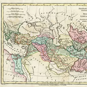
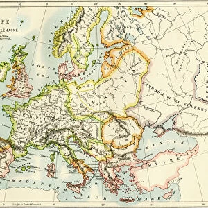
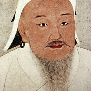
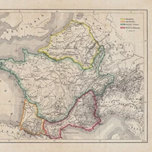
The Mongol Empire at its greatest extent : commenced by Genghis Khan in the 13th century, it was enlarged by Kublai Khan but broke up after about 1380
Mary Evans Picture Library makes available wonderful images created for people to enjoy over the centuries
Media ID 584825
© Mary Evans Picture Library 2015 - https://copyrighthub.org/s0/hub1/creation/maryevans/MaryEvansPictureID/10038070
1300 1380 13th Broke Commenced Enlarged Extent Genghis Greatest Khan Kublai Maps Mongol
FEATURES IN THESE COLLECTIONS
> Asia
> Related Images
> Maps and Charts
> Early Maps
> Maps and Charts
> Related Images
> Popular Themes
> Maps and Charts
EDITORS COMMENTS
This map print showcases the Mongol Empire at its greatest extent during the 13th century, a historical period marked by the remarkable reigns of Genghis Khan and Kublai Khan. The Mongol Empire, which commenced under Genghis Khan in the early 13th century, was initially a small nomadic confederation in the Mongolian plateau. However, under Genghis Khan's leadership, it grew into a formidable military power that conquered vast territories in Asia and Eastern Europe. Genghis Khan's successor, Ögödei Khan, continued the empire's expansion, and it was further enlarged under Kublai Khan in the late 13th century. At its peak, the Mongol Empire stretched from the Pacific Ocean in the east to the Caspian Sea in the west, and from the Arctic Ocean in the north to the Indian subcontinent in the south. The Mongol Empire's cultural and economic influence extended far beyond its borders, and it facilitated the exchange of goods, ideas, and technologies between different civilizations. The map illustrates the empire's territorial reach, with various regions labeled, including China, Persia, India, Russia, and the Middle East. This map is an invaluable historical resource, providing a visual representation of the Mongol Empire's vast territorial extent during the 13th century. It serves as a reminder of the empire's significant impact on world history and its lasting legacy. The intricate details and vibrant colors bring the map to life, making it an essential addition to any history or geography collection.
MADE IN THE USA
Safe Shipping with 30 Day Money Back Guarantee
FREE PERSONALISATION*
We are proud to offer a range of customisation features including Personalised Captions, Color Filters and Picture Zoom Tools
SECURE PAYMENTS
We happily accept a wide range of payment options so you can pay for the things you need in the way that is most convenient for you
* Options may vary by product and licensing agreement. Zoomed Pictures can be adjusted in the Cart.