Home > Animals > Mammals > Muridae > Western Mouse
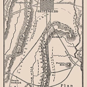
Map of the Battle of Gettysburg, Pennsylvania, 1-3 July 1863 (1862-1867). Artist: Charles Sholl
. Artist: Charles Sholl")
![]()
Wall Art and Photo Gifts from Heritage Images
Map of the Battle of Gettysburg, Pennsylvania, 1-3 July 1863 (1862-1867). Artist: Charles Sholl
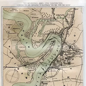
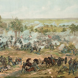
Map of the Battle of Gettysburg, Pennsylvania, 1-3 July 1863 (1862-1867). Gettysburg was the largest battle ever fought in the Western Hemisphere. Casualties on both sides were extremely heavy, amounting to some 51, 000 in all. The battle is generally regarded as marking the turning point of the Civil War in favour of the Union. An engraving from volume III of The War with the South : a History of the Late Rebellion, by Robert Tomes, Benjamin G Smith, New York, Virtue & Yorston, 3 Volumes, 1862-1867
Heritage Images features heritage image collections
Media ID 14912294
© The Print Collector / Heritage-Images
Battle Of Gettysburg Campaign Gettysburg Pennsylvania American Civil War Battlefield Print Collector4
FEATURES IN THESE COLLECTIONS
> Animals
> Mammals
> Muridae
> Western Mouse
> Arts
> Artists
> Related Images
> Arts
> Artists
> S
> Charles Smith
> Arts
> Artists
> S
> Robert Smith
> Historic
> Battles
> Battle of Gettysburg
> American history
> Historic
> Battles
> Battle of Gettysburg
> Civil War battles
> Historic
> Battles
> Battle of Gettysburg
> Historic
> Battles
> Related Images
> Maps and Charts
> Related Images
EDITORS COMMENTS
This print showcases Charles Sholl's remarkable map of the Battle of Gettysburg, Pennsylvania, which took place from July 1st to July 3rd in 1863. Known as the largest battle ever fought in the Western Hemisphere, this historic event left a profound impact on American history. The casualties suffered by both Union and Confederate forces were staggering, totaling around 51,000 lives lost. Considered a turning point in favor of the Union during the Civil War, this battle marked a significant shift in momentum. The intricate details depicted on Sholl's map provide an invaluable visual representation of the battlefield and its strategic elements. Engraved for volume III of "The War with the South: A History of the Late Rebellion" authored by Robert Tomes and Benjamin G Smith, this print offers viewers a glimpse into one of America's most pivotal moments. With vibrant colors that bring life to every inch of land portrayed on this map, it serves as a testament to Sholl's artistic talent. As we observe this piece today, we are reminded not only of the immense sacrifices made by those who fought but also how their actions shaped our nation's destiny. This photograph is more than just an image; it encapsulates an era defined by conflict and resilience—a reminder that history continues to shape our present reality.
MADE IN THE USA
Safe Shipping with 30 Day Money Back Guarantee
FREE PERSONALISATION*
We are proud to offer a range of customisation features including Personalised Captions, Color Filters and Picture Zoom Tools
SECURE PAYMENTS
We happily accept a wide range of payment options so you can pay for the things you need in the way that is most convenient for you
* Options may vary by product and licensing agreement. Zoomed Pictures can be adjusted in the Cart.