Home > Europe > United Kingdom > England > London > Boroughs > Harrow
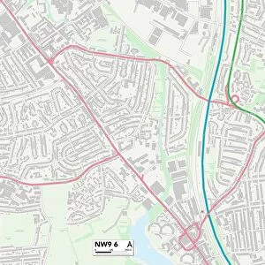
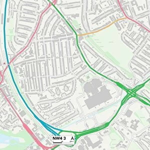
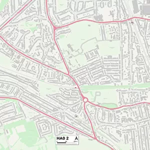
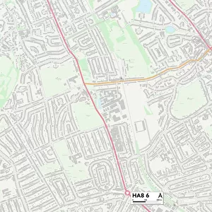
Harrow HA8 6 Map

![]()
Wall Art and Photo Gifts from Map Marketing
Harrow HA8 6 Map
Postcode Sector Map of Harrow HA8 6
Media ID 19970579
Appledore Close Bideford Close Buckingham Road Churchill Road Coombe Close Dale Avenue Dorset Drive Gresham Road Harrow Lowther Road Mead Road Merlin Crescent Methuen Road Montgomery Road Pembroke Place St Austell Close St Davids Drive St Lawrence Close Station Road Stratton Close Summit Close Taunton Way Tavistock Road Tenby Road Tiverton Road Turner Road Whitchurch Close Wychwood Close Queensbury
FEATURES IN THESE COLLECTIONS
> Animals
> Mammals
> Muridae
> Little Wood Mouse
> Europe
> United Kingdom
> England
> Dorset
> Grove
> Europe
> United Kingdom
> England
> Dorset
> Related Images
> Europe
> United Kingdom
> England
> Dorset
> Stratton
> Europe
> United Kingdom
> England
> London
> Boroughs
> Harrow
> Europe
> United Kingdom
> Wales
> Pembrokeshire
> Pembroke
> Europe
> United Kingdom
> Wales
> Pembrokeshire
> St Davids
> Europe
> United Kingdom
> Wales
> Pembrokeshire
> Tenby
> Europe
> United Kingdom
> Wales
> Powys
> Montgomery
> Map Marketing
> Postcode Sector Maps
> HA - Harrow
> Maps and Charts
> Related Images
MADE IN THE USA
Safe Shipping with 30 Day Money Back Guarantee
FREE PERSONALISATION*
We are proud to offer a range of customisation features including Personalised Captions, Color Filters and Picture Zoom Tools
SECURE PAYMENTS
We happily accept a wide range of payment options so you can pay for the things you need in the way that is most convenient for you
* Options may vary by product and licensing agreement. Zoomed Pictures can be adjusted in the Cart.