Home > North America > Mexico > Maps
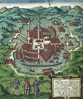
ARRIETA, Pedro (?-1738); CORREA, Diego (17th
; CORREA, Diego (17th")
![]()
Wall Art and Photo Gifts from Mary Evans Picture Library
ARRIETA, Pedro (?-1738); CORREA, Diego (17th
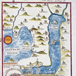
ARRIETA, Pedro (?-1738); CORREA, Diego (17th c.-18th c.). Map of Ciudad de Mexico. 1737. Oil on canvas. MEXICO. Mexico City. Chapultepec Castle
Mary Evans Picture Library makes available wonderful images created for people to enjoy over the centuries
Media ID 8280227
© Mary Evans Picture Library 2015 - https://copyrighthub.org/s0/hub1/creation/maryevans/MaryEvansPictureID/10683997
Arrieta Chapultepec Ciudad Correa Diego Mexico Oils Paintings Pedro Pictures
FEATURES IN THESE COLLECTIONS
> Aerial Photography
> Related Images
> North America
> Mexico
> Maps
> North America
> Mexico
> Mexico City
EDITORS COMMENTS
This stunning oil on canvas painting, created by the 18th century Spanish artists Pedro Arrieta and Diego Correa, depicts a bird's eye view of the Ciudad de Mexico, or Mexico City, as it appeared in 1737. The painting is currently housed in the Chapultepec Castle in Mexico City, a historic site and museum. Pedro Arrieta and Diego Correa were both prominent artists of the Spanish colonial period in Mexico. Arrieta, whose birth and death years are unknown, is known for his cartographic works, including maps and views of various Mexican cities. Correa, born in the 17th century, was a prolific painter who specialized in landscapes and historical scenes. Together, they created this breathtaking representation of Mexico City, capturing the layout of the city's streets, plazas, and buildings with remarkable detail. The painting shows the city's central plaza, the Zocalo, surrounded by the Cathedral, the National Palace, and other notable structures. The painting's vibrant colors and rich textures bring the city to life, transporting the viewer back in time to the colonial era. The painting's horizontal format also provides a unique perspective, allowing the viewer to take in the vast expanse of the city and appreciate its intricate details. The Chapultepec Castle, where the painting is displayed, is a historic site and museum in Mexico City. The castle, which was built in the 18th century, has served various functions throughout history, including as a royal residence, a military fortress, and a museum. Today, it is a popular tourist destination and a symbol of Mexico's rich cultural heritage.
MADE IN THE USA
Safe Shipping with 30 Day Money Back Guarantee
FREE PERSONALISATION*
We are proud to offer a range of customisation features including Personalised Captions, Color Filters and Picture Zoom Tools
SECURE PAYMENTS
We happily accept a wide range of payment options so you can pay for the things you need in the way that is most convenient for you
* Options may vary by product and licensing agreement. Zoomed Pictures can be adjusted in the Cart.