Home > North America > Mexico > Maps
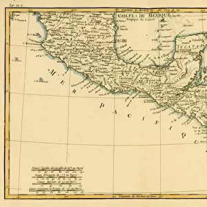
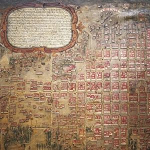
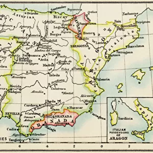
Map of the archbishopric of Mexico (1767), by
, by")
![]()
Wall Art and Photo Gifts from Mary Evans Picture Library
Map of the archbishopric of Mexico (1767), by
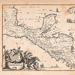
Map of the archbishopric of Mexico (1767), by Jos頁 ntonio Alzate. View of the area of Tenochtitlan, the lagoons of Chalco and Tescuco. From the Lorenzana-Borb ollection. SPAIN. Toledo. State Public Library
Mary Evans Picture Library makes available wonderful images created for people to enjoy over the centuries
Media ID 8272409
© Mary Evans Picture Library 2015 - https://copyrighthub.org/s0/hub1/creation/maryevans/MaryEvansPictureID/10686729
Antonio Area Borb Cartographic Cartographies Cartography Lagoons Maps Mexico Tenochtitlan Toledo Archbishopric Up Right
FEATURES IN THESE COLLECTIONS
> Maps and Charts
> Spain
> North America
> Mexico
> Maps
EDITORS COMMENTS
This map print, titled "Map of the Archbishopric of Mexico" (1767), showcases the meticulously detailed cartography work of the renowned Spanish cartographer, Antonio de Alzate. The map offers a vertical, or viewpoint, perspective of the central region of New Spain, with a particular focus on the area of Tenochtitlan, the ancient Aztec capital city, and the surrounding lagoons of Chalco and Tescuco. The map is part of the prestigious Lorenzana-Borbón collection, housed in the Public Library of Toledo, Spain. This collection is renowned for its extensive and valuable collection of historical maps, charts, and atlases. The map's intricate cartographic representation of the region highlights the various territories, settlements, and geographical features of the area during the late 18th century. The lush green lagoons of Chalco and Tescuco, located to the east and southeast of Tenochtitlan, respectively, are depicted with remarkable accuracy, reflecting the cartographer's expertise and attention to detail. The map's historical significance lies in its ability to provide valuable insights into the geography, settlement patterns, and administrative divisions of the Archbishopric of Mexico during the Spanish colonial period. The map's vertical orientation, a less common perspective for maps of the time, adds to its unique character and makes it a fascinating addition to any collection of historical cartography or Mexican history. The map's rich history and intricate details make it a must-see for scholars, historians, and anyone with an interest in the history of Mexico, cartography, or colonial-era Spain. The map is a testament to the skill and dedication of Antonio de Alzate and the importance of the Lorenzana-Borbón collection in preserving and showcasing historical maps and atlases.
MADE IN THE USA
Safe Shipping with 30 Day Money Back Guarantee
FREE PERSONALISATION*
We are proud to offer a range of customisation features including Personalised Captions, Color Filters and Picture Zoom Tools
SECURE PAYMENTS
We happily accept a wide range of payment options so you can pay for the things you need in the way that is most convenient for you
* Options may vary by product and licensing agreement. Zoomed Pictures can be adjusted in the Cart.